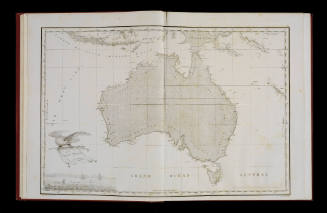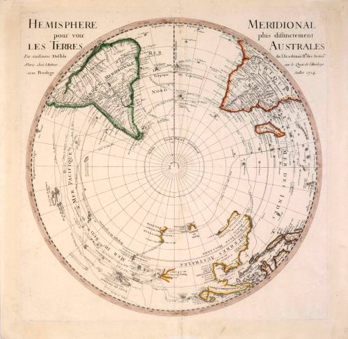
Hemisphere Meridional Pour Voir Plus Distictement Les Terres Australes
Cartographer
Guillaume de L'Isle
(1675 - 1726)
Date1714
Object number00039422
NameMap
MediumInk on paper
DimensionsOverall: 520 x 530 mm
ClassificationsMaps, charts and plans
Credit LineANMM Collection
DescriptionThis map of the Southern Hemisphere was published in Del'Isle's Atlas de Geographie around 1730. The hand-coloured print depicts the Southern Hemisphere as viewed from the South Pole - with the circumference of the engraving being defined by the Equator. It was drawn from charts dating to 1714, which contained the best available knowledge of the region's geography at the time.
Depicted on the map are the routes taken by the explorers Magellan, Medana, le Maire, Dampier, Tasman, Halley and others.HistoryGuillaume Del'Isle was a French cartographer who began recording more scientifically researched representations of the world's geography. In this respect he was innovative when compared with earlier map makers. Despite a number of errors on Del'Isle's maps he uniquely left areas he was uncertain of void, such as Antarctica and large parts of the Australian coastline. This was in contrast to the majority of map makers who improvised the details of undiscovered land masses to avoid leaving blank spaces on their maps. Del'Isle's charts depict America with a number of corrections, including the portrayal of California as part of the mainland and not an island. His mapping of Australia was one of the first known portrayals of the continent and was based on the limited survey material that was available in 1714.
The Atlas de Geographie was the largest project that Del'Isle ever worked on. It contained at least 94 hand-coloured maps of the world, including the still relatively undiscovered regions of the Pacific Ocean and North and South America.
SignificanceThis very finely detailed map is one of the earliest representations of Australia and the South Pacific. It highlights the scientific approach that cartographers were beginning to take in map making and illustrates how European knowledge of the region was beginning to expand by the early 18th century.