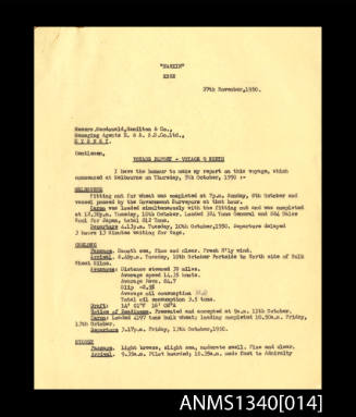
The China Navigation Company Limited - MV CHANGSHA - routes between Australian ports and ports in Asia and Papua New Guinea
Subject or historical figure
Eric Bolton Beeham
(Australian, born 1917)
Date1948-1953
Object number00036295
NameMap
MediumPaper, ink, fabric, wood
DimensionsOverall: 1155 x 915 x 15 mm, 0.46 kg
ClassificationsMaps, charts and plans
Credit LineANMM Collection Gift from Elaine Beeham
DescriptionChina Navigation Company Ltd chart map of shipping routes and distances between ports throughout the Australian Pacific region. The chart reads Australia - Manila - Hong Kong - Japan and New Guinea - Australia Line serving Port Moresby - Samarai - Lae - Madang - Kavieng - Rabaul from Melbourne - Sydney - Brisbane".
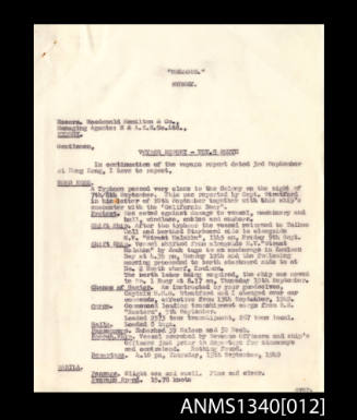
7 April 1949- 7 July 1949
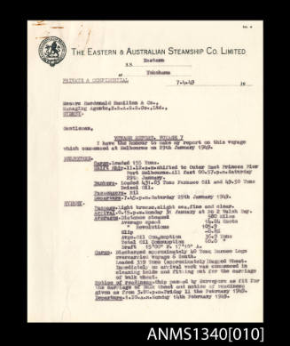
6 April 1950 - 14 August 1950

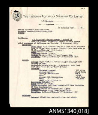
7 October 1947 - 13 December 1947
January 1951