![Koninklijke Paketvaart Maatschappij [KPM] Shipping Routes Map for Dutch East Indies](/internal/media/dispatcher/233690/preview)

Koninklijke Paketvaart Maatschappij [KPM] Shipping Routes Map for Dutch East Indies
Cartographer
Koninklijke Paketvaart Maatschappij
(1888 - 1966)
Datec 1920
Object number00049281
NameMap
MediumPaper
DimensionsOverall: 620 x 885 mm
ClassificationsMaps, charts and plans
Credit LineANMM Collection Gift from Jan Kuit
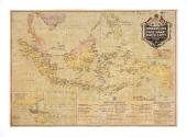
DescriptionA cloth backed colour map of the Dutch East Indies by the Koninklijke Paketvaart Maatschappj (Royal Packet Navigation Company) or KPM, showing the KPM's principal shipping services.
HistoryThis cloth backed colour map of the Dutch East Indies (now Indonesia) by the Koninklijke Paketvaart Maatschappj (Royal Packet Navigation Company) or KPM was produced in Great Britain by George Phillip & Son, London, with the imprimatuer of 'The London Geographical Institute'.
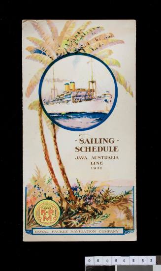
The map shows the KPM 'Principal Services' inside the Dutch East Indies and the routes and vessels on the Java-Australia Line, the TSS NIEUW HOLLAND and TSS NIEUW ZEELAND and the Deli Straits-China line, MC VAN HEUTSZ and MV CREMER.
An inset map shows these longer routes outside the Dutch East Indies and includes Australia and China.
KPM was established in Amsterdam in 1888 - initially to support routes to the Dutch East Indies but expanding to provide a service to Australia by 1908.
Holland was neutral in WW1 and the company managed to continue operating its services adding routes to Java, Bengal and China and Australia. During the depression of the early 1930s trade was hit badly and 17 ships were taken out of service. However three new liners were ordered and took over services to the Far East and South America via South Africa and Singapore.
KPM lost half of its fleet in the Pacific in World War II. After the Japanese over-ran the Dutch East Indies 30 vessels of the KPM fleet reached Australia intact and were used to support the Allied war effort in the South West Pacific. By the end of the war 98 out of a total of 146 ships had been lost.
KPM was more affected by the independence of Indonesia in 1949 than other Dutch companies. The KPM far eastern fleet merged with Java-China Paketvaart Lijnen (JCJL) to become Koninklijke Java-China Paketvaart Lijnen (KJPCL) - later to be known as Royal Inter-ocean Lines.
Royal Inter-ocean lines merged with Rotterdam Lloyd, Nederland Line and VNS to form the Nedlloyd group - the name being changed to Koninklijke (or Royal) Nedlloyd Group in 1970.
SignificanceThis map is an excellent and rare record of the height of the services of the KPM shipping line and graphically displays the then important connections with Australia.
Koninklijke Paketvaart Maatschappij
1939
Koninklijke Paketvaart Maatschappij
c 1930
Koninklijke Paketvaart Maatschappij
1920 - 1965
![Apply to the Agents KPM [Koninklijke Paketvaart Maatschappij]](/internal/media/dispatcher/200470/thumbnail)