
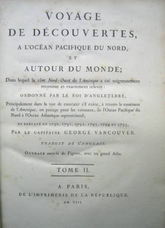
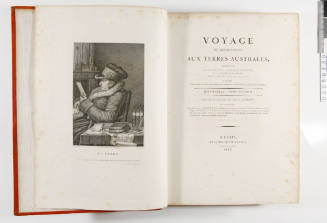
Volumes 1, 2 and 3 and atlas of Voyage de Decouvertes, a l'Ocean Pacifique du Nord et Autour du Monde
Author
George Vancouver
(English, 1757 - 1798)
Date1800
Object numberV00038267
NameBook
MediumLeather bound boards, gilt, paper, ink
DimensionsOverall: 297 x 231 mm, 1.9 kg
ClassificationsBooks and journals
Credit LineANMM Collection Acquired in memory of John Kirby by his family
DescriptionVolumes 1, 2 and 3 and atlas from the First French edition of George Vancouver's 'Voyage of Discovery to the North Pacific and Around the World ...1790-1795', Volume 1 (Paris, 1800)HistoryVANCOUVER, GEORGE (1757-1798), naval officer and hydrographer, was born on 22 June 1757 at King's Lynn, Norfolk, England, the youngest of five children of John Jasper Vancouver (d.1773) and his wife Bridget (d.1768), daughter of William Berners whose forbears included Sir Richard Grenville. At 15 Vancouver joined the navy and spent seven years under Captain James Cook during two voyages to the Pacific. In 1780 he became a lieutenant and in 1781-83 served in the West Indies. Under Sir Alan Gardner at Jamaica in 1784-89 he carried out his first independent surveys. At Gardner's suggestion he was chosen to lead an expedition to the South Seas and in 1790 was promoted commander. Instructed to negotiate with the Spaniards at Nootka Sound and to survey the north-west coast of America and well equipped with 'the latest chronometers and scientific instruments', stores and comforts, he left England in April 1791 in the new sloop DISCOVERY, 340 tons, accompanied by the armed tender CHATHAM (Lieutenant William Broughton), 135 tons.
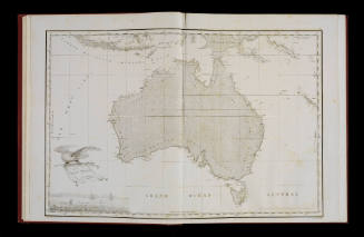
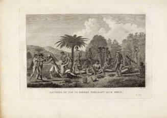
Vancouver had been given permission to examine 'that extent of coast of the south-west side of New Holland, which in the present age appears a real blot in geography'. He planned 'to fall in with the S.W. Cape of New Holland, and should I find the shores capable of being navigated without much hazard to range its coast and determine whether it and Van Diemen's Land are joined, which from all information at present extant appears somewhat doubtful'. On 26 September he sighted land near Cape Leeuwin and, sailing south-east, named Capes Chatham and Howe. Two days later the ships entered a spacious harbour which he named King George the Third's Sound. Vancouver also discovered and named Oyster Bay and other features, claiming them for Great Britain. He reported on the terrain, animal life and the native inhabitants, and planted watercress, vines, almonds, oranges, lemons and pumpkins 'for the benefit of future visitors'. On 11 October the ships journeyed east, surveying some 300 miles (483 km) of coast, 'in which space we saw no other haven or place of security for shipping than the Sound before mentioned' and, in the westernmost part of the Recherche Archipelago, reached a rocky island which Vancouver called Termination Island.
Adverse winds prevented him from examining the Great Australian Bight, and relinquishing 'with great reluctance' this 'favourite project', he sailed south of Van Diemen's Land. The two ships were separated; off the southern tip of New Zealand Vancouver encountered '7 craggy islands' which he named The Snares, and the CHATHAM discovered and named Chatham Island. Further east in the Pacific he made detailed surveys of the Tahitian and Hawaiian (Sandwich) Islands and the vast and complex north-west coast of America from a point near San Francisco to the Alaskan Peninsula, most of the work being done in open boats. On his voyage Vancouver checked earlier charts, including some by Cook, correcting them with modesty and without disparagement. At Nootka he met the Spanish representative, Don Juan Quadra, but they could not agree in interpreting their separate instructions so decided without acrimony to refer the dispute over territory to their governments.
New South Wales remained Vancouver's only link with British officials during his three years in the Pacific. Orders had been sent to Governor Arthur Phillip at Port Jackson to replenish Vancouver with supplies and equipment. The storeship DAEDALUS was sent to him, but her commander and an astronomer were murdered in Hawaii and some of the crew deserted before the ship arrived at Nootka in August 1792. Vancouver provided a new commander and as instructed sent livestock back to Sydney; his friend Don Quadra contributed a few cattle and sheep, and other animals were collected on the way, but most were lost on the voyage. The DAEDALUS also took back dispatches, a report for Governor Phillip of the survey of the south-west coast of New Holland, charts and an appraisal of the King George Sound area which Vancouver thought 'worthy of some further attention'. Phillip had returned to England but Lieutenant-Governor Francis Grose sent the DAEDALUS back to Vancouver with supplies. By December 1794 Vancouver had completed his surveys and turned homeward by way of Cape Horn and St Helena, where the CHATHAM left his command. He arrived in London in September 1795 to find he had been promoted post captain on 28 August 1794. He retired to Petersham, Surrey, to prepare a full account of his voyage and all his charts for publication, as requested by the Admiralty. His health failing he had to seek help from his brother John, who by March 1797 was doing all the writing. Five volumes were completed and the sixth was in preparation when Vancouver died. It was finished by John with aid from Lieutenant Puget and A Voyage of Discovery to the North Pacific Ocean … was published in London in 1798.
(Adapted from Australian Dictionary of Biography)
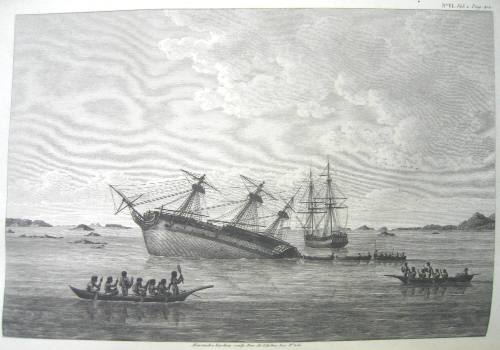
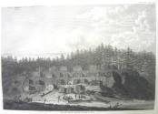
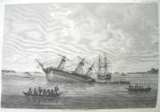
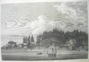
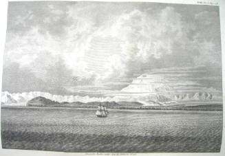
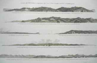
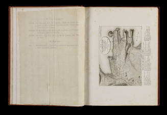
Although no official artists were assigned to Vancouver's expedition, three officers ('young gentlemen') produced drawings. These were John Sykes, Henry Humphrys (both of the DISCOVERY) and Thomas Heddington (aboard CHATHAM). The botanist Archibald Menzies also produced botanical drawings. The DISCOVERY's first lieutenant Zachary Mudge produced a watercolour of the DISCOVERY on the rocks in Queen Charlotte's Sound (Plate VI, Vol. 1).SignificanceA protégé of Cook who sailed on both his second and third voyages, George Vancouver became a gifted surveyor and cartographer in his own right. His expedition to the north Pacific detailed in this work proved to be the culmination of his career.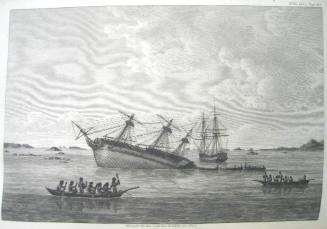
Jacques-Julien Houton de Labillardiere
1811

Parent (child)/Child (parent)