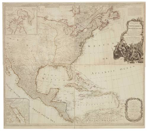
A New Map of North America with the West India Islands Divided According to the Preliminary Articles of Peace, Signed at Versailles 20 January 1783 Wherein are Particularly Distinguished The United States, and the Several Provinces Governments ect. Which Compose The British Dominions
Date1794
Object number00055392
NameMap
MediumColour print on paper
DimensionsOverall: 1055 × 1186 mm
ClassificationsMaps, charts and plans
Credit LineAustralian National Maritime Museum Collection
DescriptionA map titled 'A New Map of North America, with the West India Islands' featuring North America, Central America, the northern tip of South America and the West Indies. There are more detailed inserts of the Arctic region and the Sea of California.
The 1783 Treaty of Versailles brought a formal end to the American Revolution requiring amongst other things, agreement on boundaries of the United States. This chart provides a visual representation of the boundaries formally agreed in the Paris agreement.HistoryThe 1783 Treaty of Versailles (also known as the Paris Peace Treaty) brought a formal end to the American Revolution whereby representives of Britain and the United States signed an agreement covering territorial boundaries, restitution of property, an end to confiscations and agreement on ongoing peaceful interaction between subject citizens of he United States and subjects of George III.
Article 1 defined the states constituting the United States and their recognition by King George III:
His Brittanic Majesty acknowledges the said United States, viz., New Hampshire, Massachusetts Bay, Rhode Island and Providence Plantations, Connecticut, New York, New Jersey, Pennsylvania, Maryland, Virginia, North Carolina, South Carolina and Georgia, to be free sovereign and independent states, that he treats with them as such, and for himself, his heirs, and successors, relinquishes all claims to the government, propriety, and territorial rights of the same and every part thereof.
This map identifies the boundaries of the Unites States, British and other territories.SignificanceThe map is significant as a representation of the United States of America shortly after their formal international ratification in Paris after the American War of Independence.

1906-1911
Captain George Dixon
1789