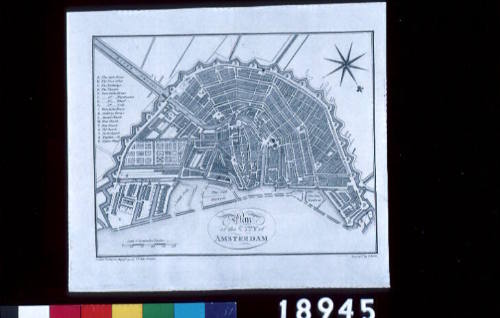
Plan of the City of Amsterdam
Engraver
Samuel John Neele
(1758 - 1824)
Author
Dr John Trusler
(1735 - 1820)
Date1791
Object number00018945
NameMap
MediumInk on paper
DimensionsOverall: 208 x 233 mm, 0.003 kg
Image: 164 x 206 mm
Sheet: 208 x 233 mm
Image: 164 x 206 mm
Sheet: 208 x 233 mm
ClassificationsMaps, charts and plans
Credit LineANMM Collection
DescriptionPublished in 1791, this map of Amsterdam, the Netherlands, is part of Rev. Dr John Trusler's (1735-1820) text 'The Habitable World Described'. This multi-volume work was one of a large number of geographical works published in London, England during this period. This map, together with other maps that appear in this text were engraved by British cartographer/engraver Samuel John Neele (1758-1824) who produced a prolific body of work in his lifetime, much of which is retained to this day.HistoryThis map is most likely to have originated as part of a text entitled 'The Habitable World Described' by Rev. Dr. John Trusler. Published in London over a number of volumes between 1787 and 1797, this text purports to give an account of all peoples around the globe, from north to south and to contain information pertaining to the situation, extent, climate, production, animals, etc of different kingdoms and states. As with most geographical works of the period it also claims to contain information on well-known discoveries, together with the latest accounts by noted historians and travellers of all nations.
Rev. Dr. John Trusler (1735-1820) was a Church of England clergyman and author, who had risen to become a renowned preacher in his Hertfordshire parish. He is known to have established a school in London devoted to the teaching of elocution and to have published memoirs of his life in 1806.
This map was engraved by Samuel John Neele (1758-1824), an important British engraver and cartographer who is known to have produced a substantial body of work including maps and portraits. He operated a print shop in London with his sons between 1782 and 1833.
Amsterdam was home to the Dutch East India Company and the layout of the streets and canals were translated into a similar layout in Batavia (the headquarters of the VOC in the East). But the hot and humid conditions of Batavia did not mesh well with the canal design and disease was rife.
SignificanceThis map is a very useful source in determining what the city of Amsterdam looked like around the end of the eighteenth century. It also provides an interesting glimpse into what one of the many British geographical publications of the late-eighteenth and early-nineteenth centuries contained. It is, after all, an incredibly detailed cartographic work for its time.
![View of VOC warehouse and wharves in Amsterdam. [GEZICHT van het OOSTINDISCH-ZEEMAGAZYN, en SCHEEPS-TIMMERWERF, te Amsterdam].](/internal/media/dispatcher/94000/thumbnail)