


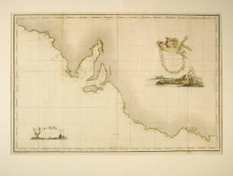
![Plate XVII [A]](/internal/media/dispatcher/98479/postagestamp)

![Plate XVIII [A]](/internal/media/dispatcher/98481/postagestamp)


Flinders Charts
Cartographer
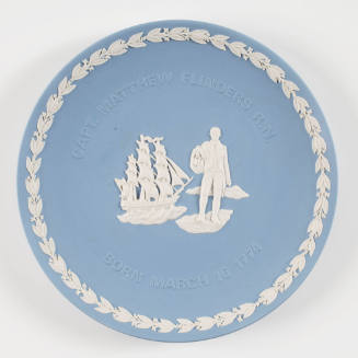
Matthew Flinders
(British, 1774 - 1814)
Date1814
Object number00003435
NameAlbum
MediumLeather, Ink on paper
DimensionsOverall: 20 x 665 x 530 mm, 430 g
Display dimensions (Open): 1080 x 660 mm
Display dimensions (Open): 1080 x 660 mm
ClassificationsMaps, charts and plans
Credit LineANMM Collection
Terms
- London
- albums
- charts
- navigation
- exploration
- King George Sound
- New South Wales
- Bass Strait
- Twofold Bay
- Cape Barren Island
- Furneaux Group
- Tasmania
- Whitsunday Passage
- Percy Isles
- Torres Strait
- Carpentaria, Gulf of
- New Guinea
- Sir Edward Pellew Group
- Arnhem Bay
- Groote Eylandt
- Timor
- Leeuwin, Cape
- Eyre Peninsula
- Thistle Island
- Schanck, Cape
- Sydney
- Sydney Heads
- Broken Bay
- Byron, Cape
- Keppel Bay
- Manifold, Cape
- Clinton, Cape
- Prince of Wales Island
- Blue Mud Bay
- Torres Strait
- Exploration and Colonisation
- Exploration and European Settlement
- Paper - archives and ephemera
HistoryMatthew Flinders was born in 1774 at Donington, Lincolnshire and joined the Royal Navy in 1789. Flinders sailed as a midshipman with Captain William Bligh on the second breadfruit expedition to the Pacific in 1791-93 and took part in the naval action the 'Glorious First of June' in 1794.
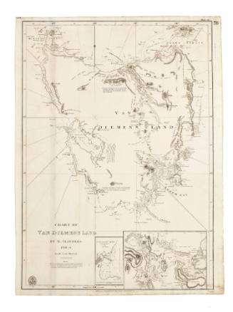
In 1795, he sailed as master's mate in the RELIANCE to the colony of New South Wales and commenced a series of investigative surveys. With George Bass, in 1796 he explored the reaches of Botany Bay in the first 'Tom Thumb', an 8-ft open boat, then in 1798, in the FRANCIS he explored the Van Diemens Land (Tasmania). In command of the NORFOLK in he proved conclusively that there was a strait between the mainland and Van Diemen's Land. In 1799 he charted areas around present-day Moreton and Hervey Bays in Queensland and returned to England in 1800.
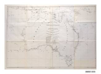
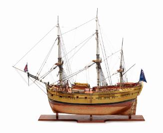
With the backing of Sir Joseph Banks, Flinders was appointed in 1801 to take command of an expedition to for the purpose of making a 'complete examination and survey' of the southern coast, the north-west coast, the Gulf of Carpentaria and parts westward, Torres Strait and if time permitted 'the whole of the remainder of the north, the west and the north-west'. Many still believed Australia to be two individual land masses separated by an inland sea.
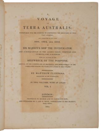
Flinders' exploration of the Australian coastline in the INVESTIGATOR and the subsequent publication of his 'A Voyage to Terra Australis', a two volume narrative with accompanying atlas, greatly enhanced Australian geography.
Flinders was returning to England on the PORPOISE in 1803 when the ship was wrecked on uncharted reefs (now called Wrecks Reef) off the Queensland coast. With 13 men he sailed back to Sydney in the ship's cutter to get help - a remarkable 1127 km (700 mile) journey.
He then returned to Wrecks Reef to rescue the survivors and continued to England, but was forced to stop in December 1803 at Ile de France (Mauritius) for supplies and repairs. As England was once more at war with France, Flinders was detained as a suspected spy for seven years. During this time he completed work on his charts and narrative and wrote a paper on a method of compensating for compass deviations caused by iron in a ship.
He was eventually released in 1810 and returned to England to complete his experiments on compass deviations, his great work 'A Voyage to Terra Australis' and his survey charts. The book was published on the day he died, 19 July 1814, aged 40.
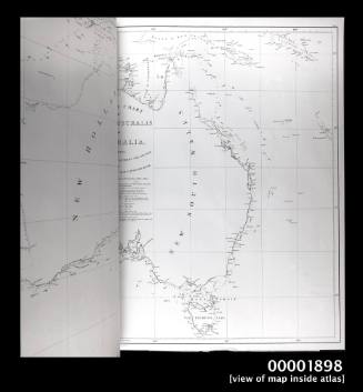
The first edition of Flinders' atlas of charts was published by G & W Nicol and bears the publishers name at the bottom of each chart. A subsequent updated edition was published by the Admiralty Hydrographic Office in 1822. Charts from this edition bear the Hydrographic Office seal, with compass rose and rhumblines.
According to the original manuscript accounts found in the Admiralty Library Archives, the total production cost of printing Flinders' work was £628:7 shillings and 6 pence, plus Paper £1452:12 shillings and 4 pence, plus engraving £58:10 shillings, making a total of £2139:9 shillings and 10 pence.
Flinders was the first to consistently use the term 'Australia' and to confirm that the west (New Holland) and the east (New South Wales) were part of the one landmass. His charts became the basis of the Australian hydrographic record.
This bound album of Flinders charts and other ephemera were collected by Thomas Walker Fowler (1859-1928), an Irish civil engineer who migrated to Australia in 1876.
Between 1882 and 1913 Fowler worked in various civil engineering positions in the northern, north-eastern, central Gippsland and southern districts of Victoria. In 1913 he was appointed engineer-in-chief of Tasmania and permanent head of the Public Works Department.
Fowler was a member of the Institution of Civil Engineers, London, and was active in many local institutions of civil, mechanical, electrical and municipal engineers. He was secretary and later vice-president of the Royal Geographical Society of Australasia (Victoria).
SignificanceThis eclectic album contains a near complete series of Matthew Flinders charts and views from his surveys of the Australian coast between 1798 and 1803, published in 1814.
These surveys of the Australian coastline are important documents in Australian history. They were the first published charts to show a quite complete picture of the Australian continent and were to cement Flinders as an iconic figure of Australian maritime history, as well as the name Australia for the continent.
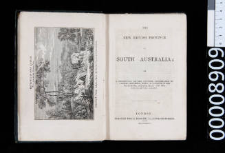
The engravings of Australian Flora are associated with Ferdinand Bauer, the French naturalist who accompanied Flinders in 1802-3. Bauer has been regarded as 'one of the finest draughtsmen in the whole history of botanic art' and some of his Australian images were reproduced in Flinders' 1814 publication A Voyage to Terra Australis.

Parent (child)/Child (parent)