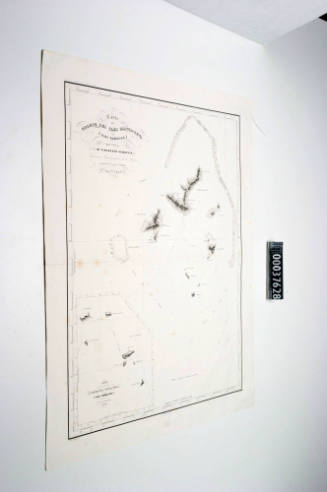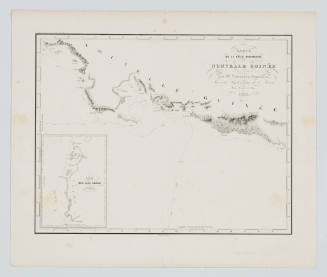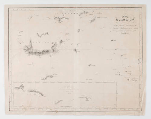
Carte de l' Archipel Viti
Maker
Clement Adrien Vincendon-Dumoulin
(French, 1811 - 1858)
Date1838
Object number00037626
NameChart
MediumInk on paper
DimensionsOverall: 430 x 550 mm, 0.01 kg
ClassificationsMaps, charts and plans
Credit LineANMM Collection
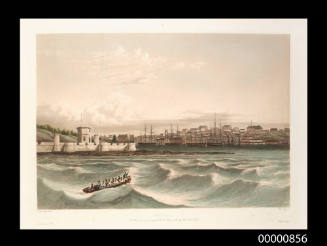
DescriptionA chart by Clement Adrien Vincendon-Dumoulin titled 'Carte de l' Archipel Viti par M Vicedon Dumoulin ingenieur hydrographe de la marine a bord de la corvette L' ASTROLABE Octobre 1838' ['Map of the Viti Archipelago M Vicedon Dumoulin engineer Hydrographer of the Navy aboard the corvette The ASTROLABE October 1838'].
The map depicts the navigation routes for the Archipelago of Viti and the islands of Samoa.
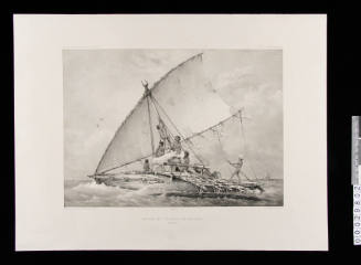
Vincendon-Dumoulin sailed with Dumont d'Urville to the Antarctic and the Pacific on the second voyage of the ASTROLABE (1837- 1840). He was responsible for drawing the first map of Adélie Land. After the expedition and D'Urville's death, Vincendon-Dumoulin acted as the principal editor of the final stages of 'Voyage au Pôle Sud'.HistoryAdrien Vincendon-Dumoulin (1811 - 1858) was a French Navy commissioner and hydrographic engineer. He was assigned to the D'Urville Antarctic expedition as hydrographer aboard the ASTROLABE.
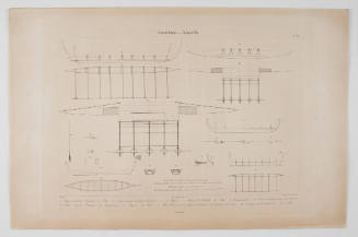
As part of his duties Vincendon-Dumoulin undertook the first inclination of the magnetic inclination and addressed the problem of making a drawing of a coast without any predetermined point and without being able to land, therefore charting whilst still under sail.
By all accounts, Vincendon-Dumoulin was a highly skilled hydrographer and his work on the voyage was recognized by d'Urville as being exceptional. On their return to Paris in 1840 he assisted Dumont d'Urville on 'Voyage au Pôle Sud' and was responsible for the 'physical and hydrography' components. When d'Urville was killed in 1842 in an accident, it was Vincendon-Dumoulin who gave a eulogy at his funeral and accorded the task of completing the final volumes of 'Voyage au Pôle Sud'.
In 1852 Vincendon-Dumoulin was back at sea on a charting expedition of Morocco, the south coast of Spain and the Strait of Gibraltar. Doing this survey he also studied currents, tides and weather conditions with his results still being used until 1986.
One negative consequence of Vincendon-Dumoulin's time with d'Urville in the southern hemisphere was the ongoing problems with his health. After the 1852 journey, his condition deteriorated and he died in 1858 at the age of 47.
SignificanceSailing three times to the Pacific, Dumont d'Urville is unquestionably the only rival to James Cook. By the 1830s however, hydrography, had become more sophisticated than in Cook's era. The detail in charts from this time, emphasise the refined engraving and attractive typography of the highest standards. This example by Vincendon-Dumoulin represents the importance France placed upon their production, being published some years after the explorer's death. It illustrates the ongoing interest of France in establishing a
strong presence in the Pacific, when Britain had largely confined itself to New South Wales and New Zealand.