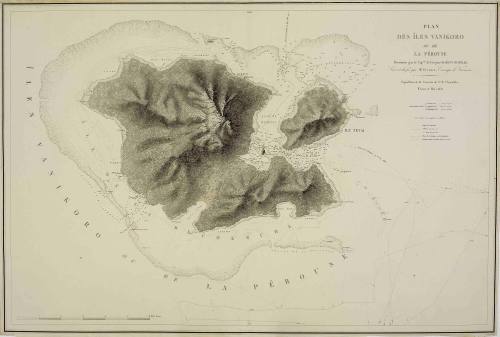
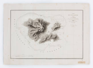
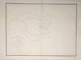
Plan des Îles Vanikoro ou de La Pérouse, reconnues par le Captaine de Frégate Dumont d'Urville
Maker
Victor Amadee Gressien
(French)
Datec 1890
Object number00047810
NameChart
MediumPaper and ink
DimensionsOverall: 602 x 901 mm
ClassificationsMaps, charts and plans
Credit LineANMM Collection
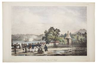
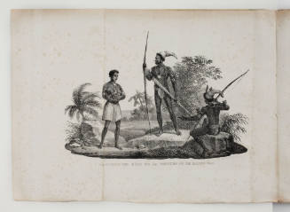
DescriptionThis very detailed chart of Vanikoro Island is based on the 1828 survey by the French naval expedition led by Jules Sebastien Cesar Dumont D'Urville. Two years earlier the Irish trader Peter Dillon had found evidence that the La Perouse expedition (missing since 1788) had perished on Vanikoro and had alerted D'Urville who was then engaged in surveying parts of New Zealand and the Pacific islands. Sailing to Vanikoro in the Santa Cruz group (Solomon Islands), D'Urville soon found shipwreck remains from the La perouse expedition - raising an anchor and several cannons and erecting a monument to La Perouse on the island.
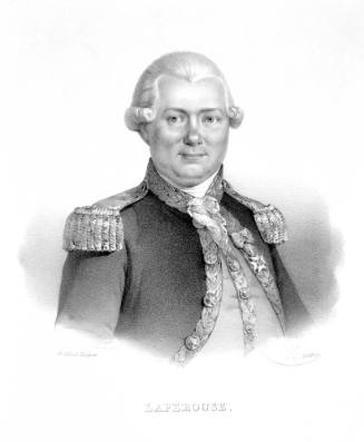
Officially recognised for his part in solving the mystery of the la Perouse expedition, Peter Dillon was awarded the Legion d'Honneur by Charles X.HistoryIn August 1785 the French navigator La Perouse sailed from France on a voyage to explore the Pacific with the ships BOUSOLE and ASTROLABE. In January 1788 the ships anchored in Botany Bay just as the ships of the First Fleet moved north to Port Jackson. The French ships remained at Botany Bay (Frenchman's Bay) until 10 March when they sailed into the Pacific. The ships were thought to be heading for Mauritius but when no news of the expedition was received by 1791, an expedition assembling under the command of D'Entrecasteaux was sent to search for the La Perouse expedition. However, despite a long search, no trace was discovered by D'Entrecasteaux and it was not until 1826 that Peter Dillon heard stories about shipwrecks at Tikopia and found traces of wreckage at Vanikoro Island in the Santa Cruz group of the Solomon Islands. In 1828 the French explorer Dumont D'Urville surveyed Vanikoro Island and erected a monument to La Perouse. Based on the 1828 survey, this chart represents the first edition.
The site of LA BOUSSOLE was not discovered until 1986 when a Franco-Australian archaeological team working with the Solomon Islands National Museum found more wreckage at a site called 'la Faille', approximately half a mile to the east of La Perouse's ASTROLABE wrecksite that had been investigated by the crews of several French naval vessels in the course of 19th century.SignificanceThe work of Peter Dillon and Dumont D'Urville finally provided closure to the mystery of what had happened to the La Perouse expedition. As the location of the disaster, Vanikoro held a special interest for explorers following in La Perouse's footsteps and Dumont D'Urville's chart is executed with particularly fine detail.
Victor Amadee Gressien
1936
Victor Amadee Gressien
1833