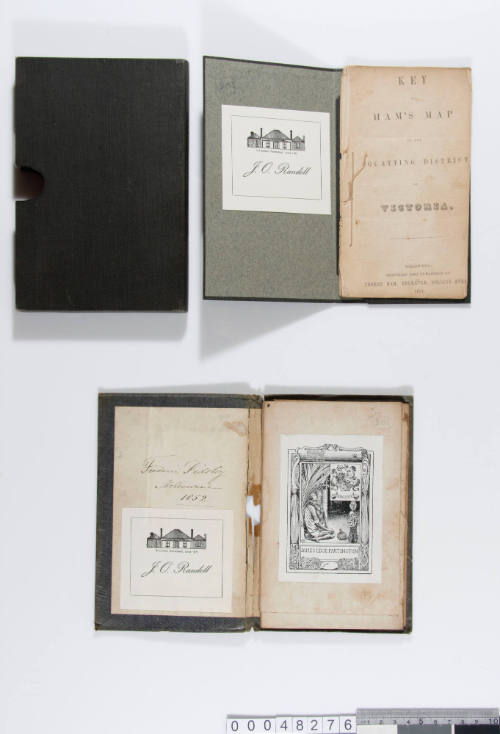

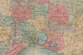
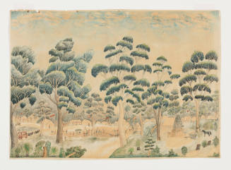
Ham's Squatting Map of Victoria
Publisher
Thomas Ham
(1821-1870)
Date1851
Object number00048276
NameMap
MediumInk on paper
DimensionsOverall: 470 x 730 mm, 240.3 g
ClassificationsMaps, charts and plans
Credit LineANMM Collection
DescriptionThis folding map backed on linen provided a practical geographical pocket guide for immigrants arriving in the new colony of Victoria, established in 1851. Following the discovery of gold near Ballarat in 1851 the population of Victoria grew from 76,000 to 540,000 in a decade as gold fever attracted people from around the world.HistoryThomas Ham (1821-1870), engraver, lithographer and publisher was the eldest son of Rev. John Ham and his wife Ann Job, née Tonkin. Thomas was born on 17 February 1821 at Teignmouth, Devon, England. The family arrived in Melbourne on the DUBLIN on 13 December 1842, intending to go to Sydney but Melbourne Baptists persuaded John Ham to stay and in July 1843 he became the first minister of the Collins Street Baptist Church. In August 1847 he resigned to go to the Bathurst Street Church in Sydney.
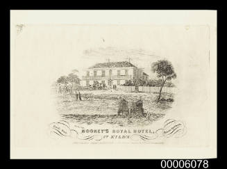
Thomas had trained as an engraver and in 1843 was commissioned to engrave the corporation seal for the Town of Melbourne. With his business in Collins Street, East Melbourne, he was sole contractor for engravings and lithography for the government and designed and engraved currency notes for various banks. He also took up land with another brother, Jabez, on the River Plenty in 1845 and in 1846-47 at Lalbert in the Wimmera district. In 1847 he published a map showing the squatting districts of 'Australia Felix'; it ran to six editions in 1851- 61. Other maps published in 1849- 54 included Melbourne and Geelong Districts (1849), Map of the Suburban Lands of the City of Melbourne (1852) and Plan of the City of Melbourne (1854). Ham lithographed the first Victorian stamps issued in January 1850: 1,800,000 'Half-length' stamps for 1d., 2d. and 3d. values, and also lithographed fifty brass cancelling-seals. In 1852 he engraved the plate for the 2d. 'Queen-on-Throne' stamps and printed 500,000 direct from the plate.
From July 1850 to August 1852 Thomas and two of his brothers jointly published the Illustrated Australian Magazine, the first of its kind in Australia. Thomas engraved and lithographed the maps and plates, many of them drawn by W Strutt. Ham's 'Five Views of the Gold Fields of Mount Alexander and Ballarat', drawn by D Tulloch, was engraved and published by Thomas in 1852, followed in 1854 by 'The Diggers Portfolio' and 'The Gold Diggers Portfolio', each with plates. In 1853 as a land and commission agent Thomas had opened the Central Land Office at 35 Swanston Street, and in 1855 was joined by his brother Cornelius in what became the long-standing firm of C J & T Ham. Thomas also opened a quartz works at Taradale in 1855 but in December 1857 joined the Victorian Geological Survey Office where he had charge of the lithography of sale plans. Four lithographs were printed from stone at lectures given by him in December 1859 and April 1860. Later that year he transferred the agency business to Cornelius and moved to Brisbane, where he was lithographer in the Survey Office from 1860 and chief engraver in 1866-70. With his brother-in-law, William Knight, he formed Thomas Ham & Co., general engravers, lithographic artists, printers and photographers, but the firm was dissolved in November 1868. With Knight, John Collings and W S Warren, Thomas then developed sugar plantations on the Albert River and later bought a farm at Redcliffe. He lithographed and published several maps in Queensland, including 'Atlas of the Colony of Queensland' (about 1868), and engraved maps for the government. He died at Brisbane on 8 March 1870.
(Text taken and adapted from the Australian Dictionary of Biography entry by Ian F. McLaren, Volume 4, Melbourne University Press, 1972, pp 328-329).
SignificanceConveniently portable in size, folding maps became popular with the increasingly literate public of the 19th century. Victoria was the only permanent British colony in Australia to be settled without the permission of the British authorities, and Ham's map is significant as a representation of land acquisition and management in the formative period of the colony of Victoria.
c 1853
John Ferres
23 September 1885