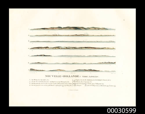
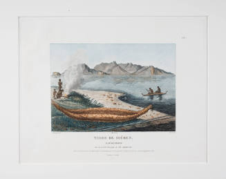
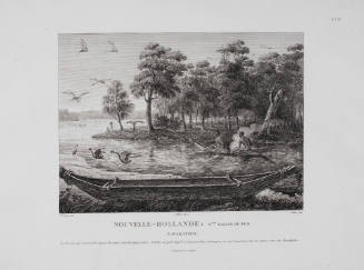
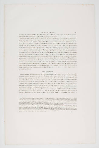
Nouvelle-Hollande: Terre Napoleon, plate V
Artist
Charles Alexandre Lesueur
(1778-1846)
Engraver
Claude-Francois Fortier
(French, 1775 - 1835)
Date1807
Object number00030599
NameEngraving
MediumInk on paper
DimensionsOverall: 267 x 358 mm
ClassificationsArt
Credit LineANMM Collection Gift from Josef Lebovic Gallery
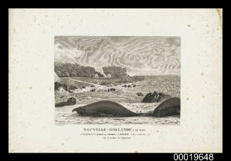
DescriptionTerre Napoleon (Land of Napoleon) was the French name for southern coast of Australia that was was surveyed by Louis Baudin aboard LE GEOGRAPHE and Louis de Freycinet, commander of the CASURINA in 1802 - 1803. The region extended from Wilson's Promontory to the Head of the Bight and French names were given to . The coastal elevations listed on this plate are :1. Cap Maringo (a) Cap Suffren (b) 2. Vue des terres de la Baie Descartes: Cap Duquene (c) Cap Montesquieu (d) 3. Vue d'une partie des cotes de la Baie Lacepede: Cap Bernouilli (e) Pointe de Nazareth (f) 4. Vue d'une partie des cotes de la presqu'ile fleurieu: Cap Lusignan (g) Cap Volney (h) 5. I. Eugene l'une des Iles Josephine, (i) i. De l'archipel s. Francois (k.L.) I. Turenne, (k) i. Lagrange (l) 6. Suite de l'archipel i. Fenelon (m) i. Talleyrand (n.) 7. S. Francois suite de l'i. Talleyrand (o) i. Malesherbes (p) i. Cuvier (q).HistoryCharles-Alexandre Lesueur joined Baudin's ship LE GEOGRAPHE at the age of 23 as an assistant gunner. His genuine interests were in natural history and he demonstrated impressive artistic skill, but this expedition by Baudin, supported by Napoleon, was so well funded and positions on board so sought after, that Lesueur semed content to be aboard in any capacity. It was said that "the most inferior stations had been sought for with avidity, and some of them were filled by young men of the most respectable families in Normandy".
Despite the attention and funding of the expedition, conditions on board the ships quickly became unbearable and by May 1802, Peron, who became Lesueur's close friend and colleague aboard wrote "The scurvy, which had succeeded to the dysentry, pervaded the ship to an alarming extent. Already several men had been consigned to the deep; already more than half of our crew were incapbale of any duty; and of our helmsmen, two alone could keep the deck. The progress of this epidemic was frightful."
Out of five zoologists orginally on board, only Peron was left. Lesuer's artistic merit had been recognised early on in the voyage and he had since been promoted to the 'honorable station of painter of natural history'. Lesueur therefore became Peron's trusted collegue and friend and together they collected around 100,000 natural specimans with Lesueur painting or drawing around 1500 images.
Both Lesueur and Peron survived the expedition and made it back to France. Peron wrote the official account of the voyage as Baudin had died in September 1803 on the Isle de France.
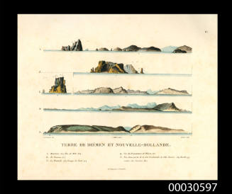
SignificanceThese coastal views were made during Louis Baudin's expedition, this set of coastal profiles is significant as one of the earliest detailed records of the southern Australian coastline.
Coastal profiles were important aids to navigation, assisting mariners to recognise their location and determine their position along a specific coast. Profiles of the shore -coastal views- were usually taken from approximately three miles out to sea together with an annotation of the point of the compass from which the profile was drawn, e.g. 'appearance from East North-East'.
Charles Alexandre Lesueur
1807
Charles Alexandre Lesueur
1807
NMC Associated/NMC Associated