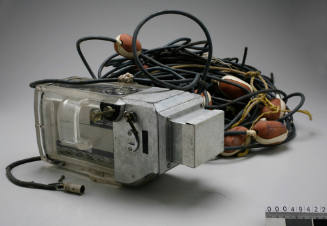
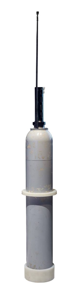
MRV SOLO II Array for Real-Time Geostrophic Oceanography (ARGO) float
Object numberV00055782
NameArgo Float
MediumMetal
DimensionsOverall (without antenna): 1200 × 185 mm
Copyright© CSIRO
ClassificationsTools and equipment
Credit LineAustralian National Maritime Museum Collection Gift of CSIRO
DescriptionArray for Real-Time Geostrophic Oceanography (ARGO) floats are a growing international network of 3,800 autonomous steel floats across the world’s oceans. They are battery-powered floats weighing about 25kg which drift within the upper 2km of the water column. Each float records coordinates, temperature, salinity and depth data continuously over a 10 day span. Every 10 days the float sinks from the surface, drifts to record at 1km and 2km depths, then rises to the surface again where it connects with a satellite. The satellite downloads the data collected which becomes publically available from Global Data Access Centres within 24 hours. An individual float can repeat this for about 8 years. It is an international collaborative effort involving over 30 countries, with ARGO Australia currently the second largest contributor. The array is not evenly spread worldwide with some areas still sparse. To keep the network going, around 800 new deployments are needed each year from national programs. Within the program’s first seven years, one million profiles had been downloaded. Technological developments are adding to the types of data a float can collect during its’ time. It also has improved the speed that data is downloaded to satellites which better safeguards floats as they can spend less time surfacing where they are more likely to be damaged.
HistoryIn the mid-1950s, John Swallow invented the principle of neutral buoyancy. The World Climate Research Programme (WCRP) aimed to collect an unparalleled set of data in 1990 for its World Ocean Circulation Experiment (WOCE). WOCE wanted to obtain data on currents in the upper 1000m of the ocean. Russ Davis and Doug Webb developed the Autonomous Lagrangian Circulation Explorer (ALACE) in 1991-1992 with Swallow’s principle. Around 1000 of these ALACE floats were deployed for the experiment. The WOCE continued through to 1997, during which improvements to the floats were made that extended their data capabilities to include temperature and salinity called Profiling ALACE (PALACE) floats.
Two scientists, Dean Roemmich and Ray Schmitt, produced papers concurrently in 1998 about the potential of profiling floats as a method of monitoring the ocean. This concept was expanded by the International Steering Team for GODAE into advocating for a global network, also backed by CLIVAR, and planning begun. Under the chairmanship of Dean Roemmich, a scientific team formed and the ARGO project commenced. Now nearly 4000 ARGO floats have been deployed since their debut in 2000.
SignificanceThe ARGO program has created a more comprehensive, and most importantly, continuous profile of the world’s oceans compared to traditional ship-based hydrography efforts. This data is used to create high-resolution ocean mapping that helps scientists calculating their climate change predictions and tropical storm forecasting. Wave height and swell data is used by oil and gas industries. Shipping industries use current speed and direction, while fisheries use ocean temperature mapping to find schools of fish.
The rate at which data can be accessed is also crucial to the industries depending on the network. The real-time data stream allows parties to see daily fluctuations. The delayed mode data stream is data available 12 months later after being highly quality-controlled. This type of data is useful for monitoring trends and making predictions.
1950s
1950s
1950s
1950s