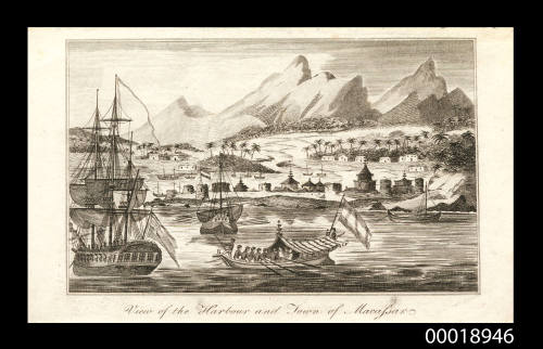
View of the Harbour and Town of Macassar
Date1806
Object number00018946
NameEngraving
MediumInk on paper
DimensionsImage: 89 x 142 mm
Overall: 103 x 171 mm, 0.001 kg
Sheet: 103 x 171 mm
Overall: 103 x 171 mm, 0.001 kg
Sheet: 103 x 171 mm
ClassificationsArt
Credit LineANMM Collection
DescriptionEngraving titled 'View of the Harbour and Town of Macassars' depicting the town and harbour viewed from the sea. A colonial Dutch fort is shown surrounded by Macassan buildings. An English ship waits outside the harbour.
Chronicles about travel and exploration became very popular in Great Britain during the second half of the 18th century. This engraving appears to have originated in one of these chronicles, although the engraver, the publisher and the author of this publication have proved difficult to discern. All that is known is that it was published in London in 1806 and that it is similar to a large number of engravings that were being published around this time that depicted European colonial outposts.
HistoryThis engraving appears to originate from one of these many chronicles. There is a lead pencil inscription above the image which reads 'Voyages of Discovery' and 'Robert Wilson', indicating either the author or the publisher of the work. Assuming this reference is accurate, the original text in which this engraving is said to have appeared in London, 1806, must be something of a rarity as there is scarcely a mention of it in the vast array of online sources available. Suffice to say that it would have been similar to other publications of the period such as John Hamilton Moore's 'A New and Complete Collection of Voyages and Travels', published in 1778 (the font of the subtitle is even similar to that which is used in this text) or 'Millar's New & Complete Universal System of Geography' published in several editions during the 1780s. Even the engraver of this portrait remains a mystery. Nevertheless, it is a valuable depiction of the colonial port-city of Macassar (or Makassar as it is more commonly known today) as it appeared at the beginning of the 19th century.
The Kingdom of Makassar, at time of Portuguese expansion in the East (16th century), was comprised of two kingdoms: Gowa and Tallo. Portuguese merchants frequented Makassar intermittently throughout the century, but their presence grew following the Kingdom's conversion Islam. By the 17th century Makassar had become the dominant trading port-city of eastern Indonesia as Makassarese kings maintained a policy of free trade, insisting on the right of any visitor to do business in the city, and rejecting the attempts of the Dutch to establish a monopoly over the city. After Malacca fell into the hands of the Dutch in 1641, the prosperity of Makassar increased even further as Portugese merchants were forced to relocate from Dutch-held territory.
However, after a bloody encounter with forces of the Dutch East India Company in 1660, a treaty was concluded between Makassar and the Dutch in which all Portugese were to be expelled from the city. Given that expelling the Portugese would have taken its toll on the highly lucrative commerce of the city, the Sultan of Makassar was able to delay carrying out the treaty obligations until as late as 1665 when the last Portugese merchants were expelled. Even so, the fact that Makassar posessed a high degree of religious tolerance ensured that it remained a valuable commercial centre for both European and Arab traders as well as for Malays working in the Spice Islands.
SignificanceAlthough little is known about the origin of this engraving, it can still be regarded as a useful source to consult when considering perceptions of European colonial outposts and their native inhabitants during the eighteenth and nineteenth centuries. This particular engraving is also very useful in its depiction of the Kingdom of Makassar, which has a particularly prominent place in both European colonial history and Indonesian history.
![The HENRI GRACE A DIEU, built in the reign of Henry 7th [1485-1509]: The SOVEREIGN OF THE SEAS, built 1637](/internal/media/dispatcher/173984/thumbnail)
Augustin Francis Bullock Creuze
1840
Valerie Taylor
1953-2000


Valerie Taylor
1953-2000