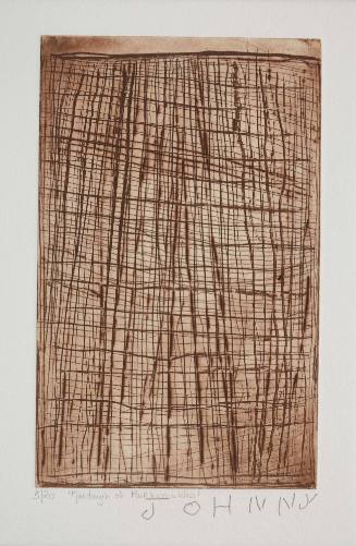
Chart No1 from Cuthro Woolshed down to Wentworth
Cartographer
James B Packer
Date19th Century
Object number00005489
NameChart
MediumSailcloth, sepia ink
DimensionsOverall: 17380 x 430 x 30 mm, 0.8 kg
ClassificationsMaps, charts and plans
Credit LineANMM Collection
DescriptionDrawn by James B Packer, this scroll-like chart was used to navigate paddle steamers down the Darling River from Cuthro (also spelt Cuthero) wool shed to its confluence with the Murray River at Wentworth.
The hand drawn chart depicts sandbanks, fallen trees, rocks, billabongs as well as homesteads, woolsheds, hotels and pubs along the length of the river.HistoryThe Darling (2,740 km), Murray (2,530 km) and Murrumbidgee (1,690 km) are Australia's three longest rivers. Crossing several states, these rivers have long been a passionately contested site for water usage, control and livelihood. Indigenous Australians had an intimate knowledge of the inland rivers and the surrounding landscape when Captain Charles Sturt set out to explore the Murrumbidgee River in 1829. He wanted to establish why the rivers in New South Wales flowed westward. By the end of 1830 he had navigated the River Murray from its junction with the Darling to its elusive southern mouth. After further explorations and overland expeditions, Sturt established that the rivers were navigable and that their surrounding sheep and cattle, people and goods could be transported between colonies, and a great overland movement began.
In 1848 representatives of station owners who had settled along the Murray and Murrumbidgee Rivers went to Adelaide to lobby the South Australian government and local businessmen to put steamers on the river. Governor Young was sympathetic to their cause and persuaded his government to award a prize to the first people to operate paddle steamers on the Murray. In 1853, the LADY AUGUSTA under Captain Francis Cadell and the MARY ANN under Captain William Randell became the first paddle steamers to travel the length of the Murray and reach Swan Hill.
Following this success, steam transport enabled a new economy to emerge and by the 1860s there were as many as 17 steamers working on the rivers. By the 1870s there were hundreds. Ship-building industries quickly grew in towns like Goolwa, Mannum, Echuca and Moama. Tradesmen and mariners came from all over the world to cash in on the opportunities to provide by the river trade. Sea and bush skills combined to craft the boats, tools and trade needed to sustain an industry founded on riverboats, and with it, to create a community identity.
Successful navigation of the rivers depended on the right water levels and an intimate knowledge of the rivers' murky, winding pathways. River captains drew their own long rolled charts marking bends, snags, properties and hotels, while powerful snagging steamers dragged the invisible river bottom clear.
By the mid-nineteenth century wool was a staple for colonial economies and steamboats on the Murray and Darling Rivers moved it to ports. They supplanted slow, expensive bullock trains, giving the wool industry a cheaper and faster river highway supporting greater flocks and clips. Despite these improvements to colonial trade and communication, the paddle steamers resulted in the colonies bludgeoning each other with tariffs for over 50 years. A string of customs houses were built along the rivers and even those who trekked beyond them to remote places such as Birdsville were met by a customs officer at the Queensland border. People moved up and down and across the Murray daily and it was an oppressive and impossible task to tax them. Folklore abounds with stories of people smuggling their shopping across the river to avoid taxes.
SignificanceThis Darling River navigation chart is a rare surviving relic relating to the era of paddle steamers on the Murray, Darling and Murrumbidgee river systems in the 19th century. Paddle steamers were the lifeblood of the river communities and the primary means of transport and trade.