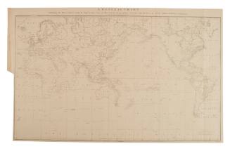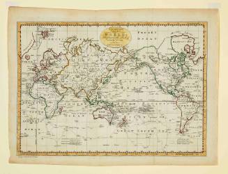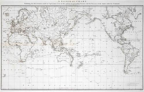
A General Chart: Exhibiting the Discoveries made by Captain James Cook in this and his two preceding voyages; with the tracks of the ships under his Command
Cartographer
Lieutenant Henry Roberts
(1756 - 1796)
Datec 1784
Object number00004857
NameChart
MediumInk on paper
DimensionsOverall: 688 x 955 mm, 1.25 kg
ClassificationsMaps, charts and plans
Credit LineANMM Collection
DescriptionMap of the discoveries of Captain James Cook by Lieutenant Henry Roberts of his Majesty's Royal Navy. The three tracking lines show the voyages of the ENDEAVOUR and the RESOLUTION for Cook's three voyages ranging from 1768-1780. Lieutenant Henry Roberts served aboard HMS DISCOVERY during Cook's third voyage and was later responsible for collating the voyage charts.
HistoryThis large map on Mercator's projection was compiled by Lieut. Henry Roberts from Captain Cook's surveys after the third expedition. The map is centered on Australasia with the routes of the ENDEAVOUR (1768-71) and RESOLUTION (1772-75 and 1776-80) illustrated with occasional notes along the tracks. Roberts began his compilation under Cook's supervision and completed it after Cook's death for inclusion in the official account of the third voyage.
SignificanceIn just over a decade Cook's expeditions transformed European knowledge of the southern hemisphere and Pacific profoundly, leaving relatively few areas untouched.