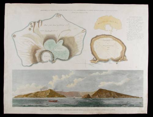
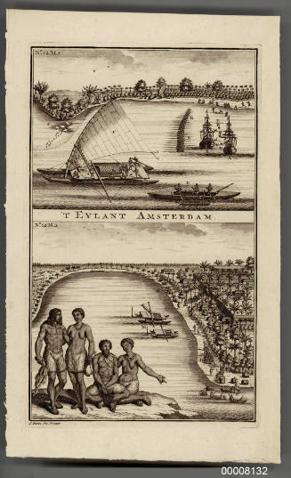
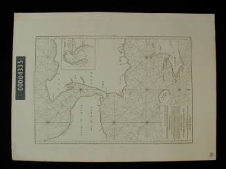
Sketches of the Island of Santo Paulo, commonly called Amsterdam, in the Indian Ocean
Engraver
William Skelton
(1763 - 1848)
Date1796
Object number00046946
NameCopper engraving
MediumInk on paper
DimensionsOverall: 422 x 551 mm
ClassificationsEphemera
Credit LineANMM Collection
DescriptionErroneously titled 'commonly called Amsterdam' on this engraving - St Paul Island lies about 85 kilometres south west of the larger Amsterdam Island. An isolated sentinel in the Indian Ocean, St Paul provided a useful reference mark for navigators wishing to check their longitude when sailing across the Indian Ocean.
HistoryFirst sighted in 1522 by the Spanish vessel VICTORIA under the command of Juan Sebastian Elcano (the only one of Magellan's fleet to return to Europe), St Paul Island was investigated in 1696 by the Dutchman de Vlaming while searching for the VOC (Dutch East India Company) ship RIDDERSCHAP VAN HOLLAND which had disappeared after leaving Batavia two years earlier.
Amsterdam Island situated 85 kilometres north west of St Paul Island was named by Anthony Van Dieman in 1633 while enroute from the Cape of Good Hope to Java.
During the 19th century the islands were visited by sealers.
The engraving was published as Plate 2 in An Authentic Account of An Embassy from the King of Great Britain to the Emperor of China, London 1797. The reference to 'Mr Parish' on the plans is to Lieutenant Henry William Parish who accompanied Lord Macartney to China (1792-94) aboard HMS LION as a surveyor. Also accompanying this first British Embassy to China was John Barrow - noted in the engraving as the original artist for the view of St Paul Island. Barrow subsequently served as Secretary to the Admiralty for over 40 years and was a great advocate of Arctic exploration.
SignificanceSt Paul Island provided a useful reference mark for navigators crossing the Southern Ocean in an age when longitude remained difficult to define successfully. The islands of St Paul and Amsterdam are significant as important marks on sea routes to Australia and Asia during the sailing ship era.
![View of VOC warehouse and wharves in Amsterdam. [GEZICHT van het OOSTINDISCH-ZEEMAGAZYN, en SCHEEPS-TIMMERWERF, te Amsterdam].](/internal/media/dispatcher/94000/thumbnail)
Augustus Charles Pugin
1806