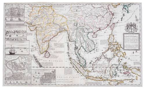
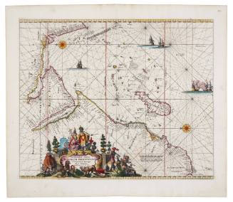
A Map of the East Indies and the adjacent Countries
Cartographer
Herman Moll
Date1715
Object number00050334
NameMap
MediumPrinting ink, handmade laid paper, watercolour (ink?) outlining.
DimensionsOverall: 615 × 1025 mm
Mount / Matt size (G Fini Mount): 900 × 1249 mm
Mount / Matt size (G Fini Mount): 900 × 1249 mm
ClassificationsMaps, charts and plans
Credit LineANMM Collection
DescriptionThis highly detailed map of the East Indies by Herman Moll provides a snap-shot of European trading interests in Asia at the beginning of the 18th century. The initial exploration and charting of parts of the Australian coast were a direct result of the growth of such centres and the opening up of shipping routes between Asia and Europe.
HistoryBorn in the Netherlands, Herman Moll (1654?-1732) was a bookseller, geographer and engraver. Around 1678 he moved to London where for a while he continued as an engraver. Later, he started his own business as a map publisher and by the turn of the century had become the most prominent map publisher in England. He published atlases and loose maps of all parts of the world many of which were highly decorative.
Included amongst Moll's associates were Daniel Defoe, Jonathan Swift (he provided maps for Robinson Crusoe and for Gulliver's Travels), and the buccaneers William Dampier and Woodes Rogers.
Bearing the coat of arms of England's East India Company, the map details the network of European trading centres throughout Asia in the early 18th century.
SignificanceThis early 18th century map of Asia reveals the extent and interest of European nations such as England, Spain, Portugal, France, Holland and Denmark in the rich trading opportunities of Asia. The settlement of Australia took place against the background of such trade and the English East India Company's monopoly influenced early Australian colonial enterprise to a considerable extent.
![Carte des Indes Orientale [Map of the East Indies]](/internal/media/dispatcher/238516/thumbnail)