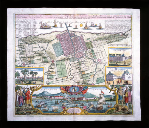
Der Hollaendisch-Ostindianischen Compagnie weltberuhmte Haupt-Handels und Niederlags-Stadt Batavia, in Asien auf dem grossen Eyland Iava in dem Konigreich Iacatra ...
Maker
Homann Erban
(German, 1730 - 1852)
Date1733
Object number00027254
NameMap
MediumHandcoloured print on paper
DimensionsOverall: 456 × 535 mm, 0.05 kg
Sheet: 510 × 603 mm
Image: 455 × 535 mm
Display dimensions (D Fini Frame): 660 × 895 mm
Mount / Matt size (D Fini Mount): 630 × 865 mm
Sheet: 510 × 603 mm
Image: 455 × 535 mm
Display dimensions (D Fini Frame): 660 × 895 mm
Mount / Matt size (D Fini Mount): 630 × 865 mm
ClassificationsMaps, charts and plans
Credit LineANMM Collection
DescriptionA map titled 'Der Hollaendisch-Ostindianischen Compagnie weltberuhmte haupt - handels und niederlags - stadt Batavia, in Asien auf dem grossen eyland Iava in dem Konigreich Iacatra e vord - westlich gelegen, nach ihrem grund ris und prospect mit erlauterung einiger ihrer befendersten merkwurdigkeiten, auf das accurateste vorgestetlet von Homannischen Erben'.
This map depicts an aerial view of Batavia (present day Jakarta) whilst under control of the VOC (Dutch East India Company). It shows its fort, defences and public buildings laid over a network of canals and waterways with rice fields and hinterland beyond. It was produced in Nuremberg, Germany, in 1733.
A numbered key identifies sites of importance. An inset at centre right entitled 'Das Rath-Haus' depicts the Council chamber. An insert located directly below is entitled 'Prospect des castels von innen, mit des herrin gouverneur - generals bewachnung' and depicts the Governor-General's guardhouse. Located across the bottom of the map is a ornately framed panorama of the city from the sea entitled 'Prospect von Batavia von der morgan seite anzusehen' depicts a view of Batavia from the east and includes illustrations of the castle, the harbour works, and public buildings with mountains in the background. Ships of various nationalities can be seen offshore.
HistoryDutch trade in the Far East was a one-way enterprise. The demand for Eastern goods in Europe far outweighed the practically non-existent demand for Western goods in Asia. Local and regional trade was an important part of the enterprise. VOC (Dutch East India Company) ships carrying silver from the Netherlands could acquire silk in China, which could then be traded for copper and gold in Japan, which, in turn, could be traded for textiles in India and so on. A well-situated headquarters was clearly needed in the region to manage the Eastern end of the VOC's affairs.
In September 1602, a Dutch resident Governor General was appointed to the East Indies. His task was to look after all major questions of a political nature as well as, when deemed necessary, to administer military matters. The first three Governors found it very difficult to promote the imperialistic aims of the Company, given the extensive amount of travel that was required of them. It was only when longtime VOC employee Jan Pieterszoon Coen was appointed to the post in 1618, that the city of Batavia (now Jakarta) was established on the island of Java and designated as the Dutch administrative centre in the Far East.
SignificanceThe Dutch settlement of Batavia was the main base for exploration and trade by the Dutch in the Asian region during the 17th and 18th centuries. This map and text provide details of Dutch infrastructure on the island in the early 18th century.
Oskar Speck
6 September 1938
Samuel J Hood Studio
May 1938
Samuel J Hood Studio
May 1938

Samuel J Hood Studio
May 1938