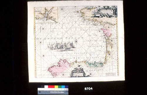
Galliae, Biscajae et Gallissiae Sinus
Maker
I and R Ottens
Date1715
Object number00008704
NameChart
MediumInk on paper
DimensionsOverall: 480 x 542 mm
ClassificationsMaps, charts and plans
Credit LineANMM Collection Gift from Cabinet of Discoveries
DescriptionA coloured chart of the Bay of Biscay showing the coastline of western France from Brittany to Gascony and northern Spain from Basque Country (Vizcaya) to Galicia. The title 'Galliae, Biscajae et Gallissiae sinus' appears top right corner. At top left corner there is an inset map of the port of Lorient in Brittany titled 'Le port de Lorient' where the French East India Company had its warehouses and shipyards. At centre there is a vignette of a naval battle. At bottom centre there is a cartouche with the inscription 'De Bocht van Vranckryck Biscajen en Galis sen' and 'Gedruckt by R. & L. Ottens'.
Archives du Muséum d'Histoire Naturelle, Paris
c 1861

![Carte des Indes Orientale [Map of the East Indies]](/internal/media/dispatcher/238516/thumbnail)