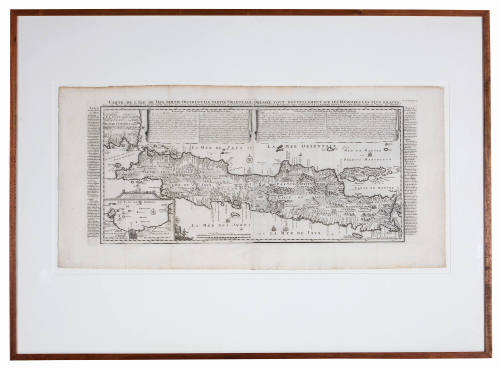


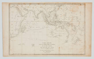
Carte de l'Ile de Java partie Occidentale partie Orientale dresse tout Nouvellement sur Les Memoires les plus exacts
Cartographer
Nicolas Guedeville
Date1720
Object number00008541
NameMap
MediumInk on paper
DimensionsOverall: 490 × 1010 mm
Mount / Matt size (G Fini Mount): 900 × 1249 mm
Mount / Matt size (G Fini Mount): 900 × 1249 mm
ClassificationsMaps, charts and plans
Credit LineANMM Collection Gift from Cabinet of Discoveries
DescriptionMap titled 'Carte de l'Ile de Java partie Occidentale partie Orientale dresse tout Nouvellement sur Les Memoires les plus exacts' ('Map of the island of Java Eastern part Western part draws on all Newly The most accurate Memories'.)
This map was published in 1720 as Plate 47 in Volume 5 of Henri Chatelain's and Nicolas Guedeville's ' Atlas historique ou nouvelle introduction a l'histoire'.
It depicts the western and eastern parts of the island of Java, and the island of Madura and part of Sumatra. The map shows the main towns of the island, position of factories and other places owned by the Dutch with additional remarks relating to the way the Dutch settled in the town of Batavia. An insert map of Batavia appears in the lower left corner.HistoryDuring the 1600s the Dutch East India Company or Vereenigde Oostindische Compagnie (VOC) was a rapidly expanding merchant organisation. The VOC established a trade network throughout Asia by transporting rare spices, exotic textiles and seeking new markets for their goods. These Asian goods were highly sought after in Europe, allowing the VOC to establish a profitable enterprise between Europe and the East Indies.
In addition to demand for foreign goods there was a growing interest in the lands themselves. The public had a huge appetite for tales from the east. The enormous Dutch publishing industry saw this a profitable market and produced an extensive range of travel memoirs, both real and imaginary, atlases and historical books.
Once such publishing house was Francois L'Honore and Company (the Chatelain family in Amsterdam) who published 'Atlas historique ou nouvelle introduction a l'histoire'.
In the preface of the first edition of the 'Atlas historique' Nicolas Guedeviile explains that the aim of the work was foremost popular, "The story of history, he said, is of vital importance for one’s education, and a great source of moral teaching. But it is also full of difficulties, obscurities and complications, and sometimes dull. The intention of ‘Atlas historique' is to make the study of history agreeable and accessible to all ages. For this reason the author has also included geographical and chronological information which is inseparable from the study of history. We have to know not only what happened, but where and when it happened. The originality and great value of the 'Atlas historique' is that, for the first time, it beings all this material together in such a way that it is immediately available to the reader, in a well laid out and digestible form. In addition there are many visual aids in the form of maps, chronological and genealogical charts and portraits that allow the reader to visualize and memorize the events, people and places referred to. For those who prefer to simply read, there are dissertations, separated from the explanations of the maps and other materials. "
("Nicolas Guedville and his Work", Rosenburg, Aubrey, Martinus Nijhoff Publishers, 1982, pp. 77).
SignificanceThe Dutch settlement of Batavia (now Jakarta, Indonesia) was the main base for exploration and trade by the Dutch in the Asian region during the 17th and 18th centuries. This map and text provide details of Dutch infrastructure on the island in the early 18th century.
Gabriel De Foigny
1692
Louis Auguste de Sainson
1826 - 1829
Jacques Etiene Victor Arago
1825

Jacques Etiene Victor Arago
1825