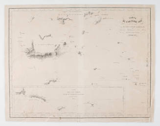
Route Chart Illustrating Routes in The Philippine Islands and East Indies Area
Date1977
Object number00056222
NameChart
MediumPaper
DimensionsOverall: 622 × 735 mm
ClassificationsMaps, charts and plans
Credit LineAustralian National Maritime Museum Collection Gift from Captain Anthony Leonard Eccleston RAN
DescriptionMap titled 'Route Chart Illustrating Routes in the Philippine Islands and East Indies Area'. Under the title, there is a disclaimer in capital letters that reads ‘Not To Be Used for Navigation’.
There is a route marked in red pencil along the coast of the Indonesian islands, from the bottom of the Malay peninsula to the Darwin coast. The back of the chart has a world map and a map titled 'Island Passages of the Philippine Islands' on the right.
This is a route chart for the area between China and Australia, showing commong shipping routes.HistoryThis map is part of a series of maps that contain notes and improvised navigational information for a journey by boat beginning in Vietnam or one of its neighbouring countries and ending in Darwin, Australia. Most of the maps are either hand drawn or repurposed from other charts, which were not supposed to be used for real navigation. Using them to brave the long and arduous journey to Australia would have been a risky and challenging endeavour.
The refugee vessel TU DO, which is in the possession of the Australian National Maritime Museum, arrived in the same year that these maps were either created or used. Its owner also used a map from a school atlas to bring more than 30 people to Australia.SignificanceThese maps and calculations belong to a rare type of object: improvised navigational instruments that were not destroyed or forgotten after the journey they were used on ended. Very few seem to have survived. The owner of the refugee vessel TU DO, which arrived in the same year that these maps were either created or used, also used only a page from a school atlas for navigation. TU DO is now in the possession of the Australian National Maritime Museum.

China Navigation Company Ltd
1948-1953