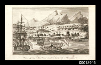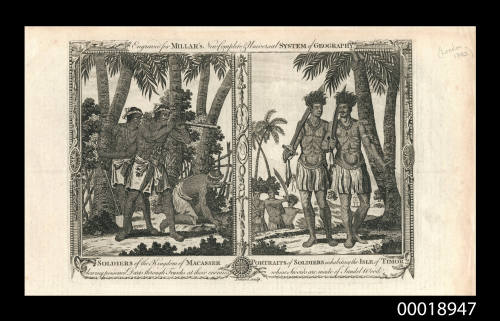
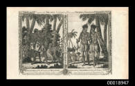
Soldiers of the Kingdom of Macassar / Portraits of Soldiers Inhabiting the Isle of Timor
Engraver
Robert Pollard
(1755 - 1839)
Date1782
Object number00018947
NameEngraving
MediumInk on paper
DimensionsOverall: 224 x 365 mm, 0.006 kg
Image: 157 x 264 mm
Sheet: 224 x 365 mm
Image: 157 x 264 mm
Sheet: 224 x 365 mm
ClassificationsArt
Credit LineANMM Collection
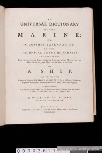
DescriptionThese portraits were originally engraved about 1778 to be used in John Hamilton Moore's 'A New and Complete Collection of Voyages and Travels'. The version that appears in this collection, however, appears to have been published in about 1782. The overhead title, together with the style of border suggests that it was part of 'Millar's New & Complete Universal System of Geography' by George Henry Millar et al; an edition which was published by Alexander Hogg in London in 1782. This book claims to include "... the most remarkable voyages and travels... from the earliest times to the present year…"HistoryThe Kingdom of Makassar (erroneously referred to in this portrait as Macasser), at the time of Portuguese expansion in the East (sixteenth century), was comprised of two kingdoms: 'Gowa' and 'Tallo'. Portuguese merchants frequented Makassar intermittently throughout the century, but their presence grew following the Kingdom's conversion to Islam. By the seventeenth century Makassar had become the dominant trading port-city of eastern Indonesia as Makassarese kings maintained a policy of free trade, insisting on the right of any visitor to do business in the city, and rejecting the attempts of the Dutch to establish a monopoly over the city. After Malacca fell into the hands of the Dutch in 1641, the prosperity of Makassar increased even further as Portugese merchants were forces to rellocate from Dutch-held territory.
However, after a bloody encounter with forces of the Dutch East India Company in 1660, a treaty was concluded between Makassar and the Dutch in which all Portugese were to be expelled from the city. Given that expelling the Portugese would have taken its toll on the highly lucrative commerce of the city, the Sultan of Makassar was able to delay carrying out the treaty obligations until as late as 1665 when the last Portugese merchants were expelled. Even so, the fact that Makassar posessed a high degree of religeous tolerance ensured that it remained a valuable commercial centre for both European and Arab traders as well as for Malays working in the Spice Islands.
Timor is an island at the south end of the Malay Archipelago, north of the Timor Sea. The Portuguese were the first Europeans to colonise the Malay archipelago when they arrived in the sixteenth century. They established outposts in the Maluku Islands and Timor and surrounding islands. During the House of Habsburg's rule over Portugal (1580-1640), all surrounding outposts were lost and eventually came under Dutch control by the mid-seventeenth century. Effective European occupation of a small part of the territory only began after 1769, when the city of Dili, the capital of so-called Portuguese Timor, was founded.
The island has been politically divided into two parts for centuries: West Timor, which was known as Dutch Timor from the 1800s until 1949 when it became Indonesian Timor, a part of the nation of Indonesia which was formed from the old Netherlands East Indies; and East Timor which was known as Portuguese Timor, a Portuguese colony until 1975. It includes the enclave of Oecussi-Ambeno in West Timor. The Netherlands and Portugal did not formally resolve the matter of the boundary until 1912.
Historical background of the publication:
Chronicles about travel and exploration became very popular in Great Britain during the second half of the eighteenth century. In part, this was due to the increasing amount of knowledge geographers had at their finger tips (the Age of Discovery was slowly drawing to a close).
These portraits were originally engraved about 1778 to be used in John Hamilton Moore's 'A New and Complete Collection of Voyages and Travels' which was purported to describe, "…in the most accurate manner, every place worthy of notice, in Europe, Asia, Africa, and America ..." This included descriptions, images and accounts of voyages by James Cook, Tobias Furneaux, Ferdinand Magellan, Francis Drake, George Anson, William Dampier, Samuel Wallis and other great explorers. The work was, according to Moore, "…embellished with a superb and elegant set of copper plate engravings and maps". The book was published in London by Alexander Hogg, a bookseller and publisher of the period.
It has become obvious, however, that these engravings were subsequently used by other authors in other publications. The version that appears in this collection appears to have been published in about 1782 and there are subtle differences to the original, including a different title above the images and the addition of some elaborate border art. The portraits themselves, however, together with the subtitles, remain the same in both versions.
The overhead title, together with the style of border suggests that this particular engraving was part of 'Millar's New & Complete Universal System of Geography' by George Henry Millar et al; an edition of which was indeed published by Alexander Hogg in London in 1782. As with Hamilton Moore's previous work, this book claims to include "... the most remarkable voyages and travels... from the earliest times to the present year…"
The only clue as to this engraving's artist is the name 'Pollard' (who, while he may be the artist of this particular copy, was not necessarily involved in the creation of the original 1778 version). Although the name was not uncommon in Britain during the eighteenth century, it is fair to assume that the 'Pollard' in question is Robert Pollard, born about 1755 in Newcastle, England. He began his career as a painter of landscapes and marine subjects before travelling to London to become an engraver in the book trade. He established himself as a publisher in 1779, issuing a wide range of decorative, patriotic and topographical prints. He is known to have collaborated with fellow engraver Francis Jukes, sometimes on his own designs. He died in 1839. Although many of his most well-known works do not closely resemble the style featured in this particular engraving, the fact that this is just a copy of someone else's work and that Pollard is known to have issued topographical prints that would have been suitable for use in works like 'Millar's New & Complete Universal System of Geography' may be inference enough.
SignificanceMillar's New & Complete Universal System of Geography has been regarded as one of the finest geographical works ever published. It is also an exceedingly useful text to consult when considering English mentalities and perceptions of European colonial outposts and their native inhabitants during the eighteenth and nineteenth centuries. This particular engraving is also very useful in its historic depiction (if be it a Eurocentric depiction) of both the Kingdom of Makassar and the island of Timor, both of which have a prominent place in both European colonial history and Indonesian history.

Daniel Lerpiniere
1782