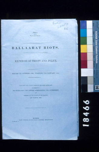
Australian Lighthouses: Papers Relative to the Lighthouses on the Australian Coast
Printer
John Ferres
Date1856
Object number00004083
NameParliamentary paper
MediumInk on paper
DimensionsDisplay dimensions: 355 x 222 x 13 mm
ClassificationsEphemera
Credit LineANMM Collection
DescriptionThis parlimentary paper 'Australian Lighthouses: Papers Relative to the Lighthouses on the Australian Coast' was presented to both the upper and lower houses of parliment in 1856. It includes a report by NSW, Victorian, South Australian and Tasmanian commissioners on the subject of lighthouses across the Australian colonies.HistoryThe report of the "Colonial Lighthouse Commission, or of the Commissioners appointed by the Governments of New South Wales, Victoria, Tasmania, and South Australia, to confer upon the subject of lighthouses in the several Australian Colonies”, has been published by the South Australian Government. The result of this Commission has already been given to the public, and the recommendations included in the report are being carried out. The Commissioners, it appears; had considerable difficulty in deciding on the position for a light on Wilson's Promontory, but after taking various observations, they fixed upon the south-eastern pitch of the promontory, for reasons which they explain in their report. The expense of this light is to be borne by Victoria and New South Wales.
The south-eastern pitch of the promontory was next examined, and found to afford advantages of position superior to what had been contemplated. The extreme point consists of a bold headland of granite formation, level on its surface, and standing at an elevation of about 300 feet: landing was affected in its immediate vicinity with facility, and no engineering difficulties appeared to present themselves, which could prevent the construction of a lighthouse at a moderate cost.
Observations were taken by the Marine Surveyor from a spot selected by the Commissioners, which gave a clear sea horizon of nineteen points of the compass, viz from Cape Wellington bearing north 43 ° east, to the southern extremity of Cleft Island, bearing south 72 ° west. To vessels approaching from the north-east this light will be visible under ordinary circumstances, at a distance of twenty-five miles, or nine miles to the north east of the Seal Islands, and, when shut in by Cape Wellington, will warn the navigator of a too near approach to the shoals in the vicinity of Corner Inlet. In approaching the promontory from the westward the light, open off Cleft Island, will enable vessels to change course with confidence, clear of the dangers in this locality; whilst to vessels from Port Philip bound to the eastward, this light will be invaluable. Having taken a departure from the lighthouse on Cape Schanck, and continued on the usual course for fifty-two miles, the light on Wilson’s Promontory will show clear of the south end of Cleft Island a distance of fourteen miles.
The position of the hidden dancers in the vicinity of the promontory, being within the radius of this light, will also be clearly pointed out. In the immediate vicinity of this headland, ample shelter can be obtained in Waterloo Bay, which was found to be not only available during westerly gales, but also capable of affording shelter to small vessels in southerly gales. Wood and water are also to be procured in abundance; and in the establishment of this light, the commissioners would recommend that it be placed on a tower fifty feet high, and be affixed catoptric light of the first class.
Source: ‘Miscellaneous Shipping’, The Hobarton Mercury (Tasmania, 1854 - 1857), Wednesday 7 January 1857, page 2.
after 1886
John Ferres
23 September 1885
20th century