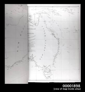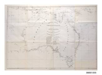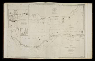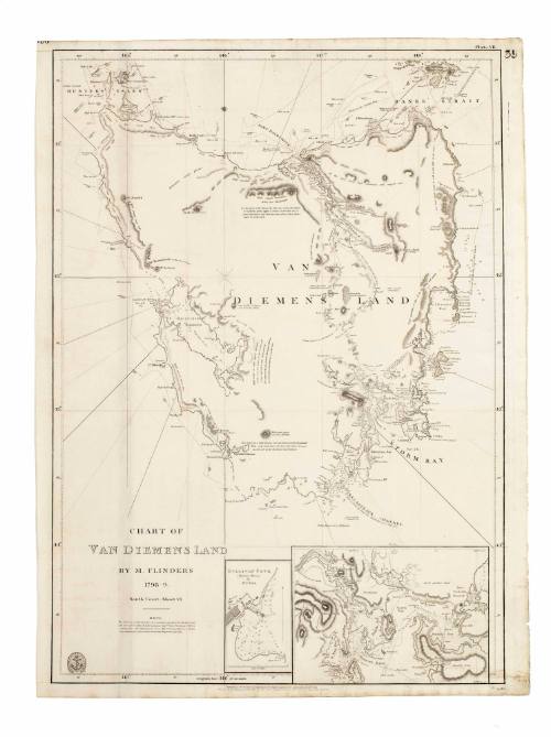
Chart of Van Diemens Land, 1798 - 1799
Cartographer
Matthew Flinders
(British, 1774 - 1814)
Engraver
L Welsh
Date1840
Object number00004101
NameChart
MediumInk on paper
DimensionsOverall: 745 × 550 mm
Mount / Matt size (E Fini Mount): 1012 × 735 mm
Mount / Matt size (E Fini Mount): 1012 × 735 mm
ClassificationsMaps, charts and plans
Credit LineANMM Collection
DescriptionThe original map for this 1840 issued chart of Van Diemen's Land (Tasmania) was produced by Matthew Flinders for the Admiralty's Hydrographic Office in 1814. It shows Van Diemen's Land with inset maps of Hobart Town (Storm Bay) and Sullivan Cove (Hobart Town). The original survey work was conducted by Flinders on an expedition to define Tasmania's coastline in 1798 to 1799.HistoryVan Diemen's Land was named in honour of the Governor of Batavia by the Dutch explorer Abel Tasman in 1642. It was assumed to be part of the Australian mainland until 1798, when Matthew Flinders with surgeon George Bass circumnavigated the Tasmanian coastline in the schooner NORFOLK. Flinders produced surveys of the Australian coast with subsequent additions such as the inset plan of Sullivan Cove, settled in 1804 and later known as Hobart Town. The name Tasmania was only adopted in 1853.
Matthew Flinders was the first European to circumnavigate Australia and prove that New Holland and New South Wales was one continent. He was also the first to consistently use the term 'Australia'. His charts were so accurate that many were still in use well into the 20th century.
With the explorer Bass he confirmed that Van Diemen's Land was indeed separate from New South Wales. With the backing of the notable and highly respected Sir Joseph Banks, Flinders was appointed to take command of an expedition to 'New Holland for the purpose of making a complete examination and survey' of the southern coast, the north-west coast, the Gulf of Carpentaria and parts westward, Torres Strait and if time permitted 'the whole of the remainder of the north, the west and the north-west'. He was also to establish if there was an inland sea. (At that time there was a suggestion that Australia was indeed two halves - New Holland to the west and New South Wales to the east - separated by a large sea).
From 1801-1803 he did his utmost to carry out the orders of the Admiralty - with one ship, HMS INVESTIGATOR. This ship was finally condemned as unseaworthy and Flinders set sail for England with his charts and specimens (for Sir Joseph) in the PORPOISE and CATO.
However Flinders ship was wrecked on uncharted reefs (now called Wrecks Reef) off the Queensland coast. With 13 men he sailed back to Sydney in the ship's cutter to get help - a remarkable 1127 km (700 mile) journey.
He returned to Wrecks Reef to rescue the survivors and continued to England, but was forced to stop in December 1803 at Ile de France (Mauritius) for supplies and repairs. As England was once more at war with France, Flinders was detained as a suspected spy for seven years. During this time he completed work on his charts and narrative and wrote a paper on a method of compensating for compass deviations caused by iron in a ship.
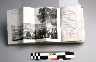
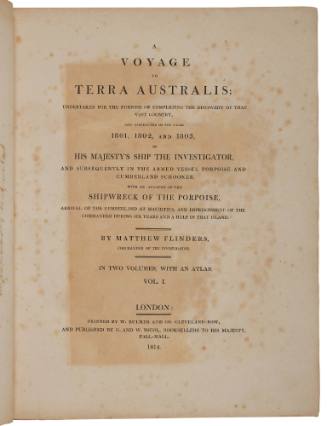
He was eventually released in 1810 and returned to England to complete his experiments on compass deviations, his great work 'A Voyage to Terra Australis' and his survey charts. The book was published on the day he died, 19 July 1814, aged 40.
Flinders charts were published as a series by the Hydrographic office the same year. This chart is plate number 7 in the series. It is title 'South Coast Cheet VI Van Diemens Land'.SignificanceThis chart reflects European exploration of the Australian mainland and the island of Tasmania and is the first official chart indicating that the two were in fact separated by Bass Strait.
Flinders was the first to consistently use the term 'Australia' and his charts became the basis of the Australian hydrographic record.