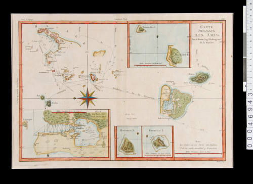
Carte des Isles des Amis (Chart of the Friendly Isles)
Cartographer
Rigobert Bonne 1727-1795
Date1790
Object number00046943
NameChart
MediumInk on paper
DimensionsOverall: 406 × 517 × 2 mm
Mount / Matt size (B Fini Frame Mount): 407 × 560 mm
Mount / Matt size (B Fini Frame Mount): 407 × 560 mm
ClassificationsMaps, charts and plans
Credit LineANMM Collection
DescriptionThis 1790 chart by the French cartographer Rigobert Bonne shows Captain Cook's route through the Tongan archipelago during his second and third voyages. The longitudes shown are based on Paris as the Prime Meridian.HistoryRigobert Bonne (1727-1795) was one of the most important cartographers of the late 18th century. In 1773 Bonne succeeded Jacques Nicolas Bellin as Royal Cartographer to France in the office of the Hydrographer at the Depôt de la Marine. His work represents an important step in the evolution of cartography, moving away from the highly decorative charts of the 17th and early 18th century towards more accurate and practical works.
Named by Cook the Friendly Islands following his first visit in October 1773, the Tongan islands were earlier visited by Abel Tasman in 1643. Tasman named Tongatapu Amsterdam island, and its northern neighbour Middleburg island.
The chart is a compilation from Cook's second and third voyages and shows the tracks of Cook's ships RESOLUTION and ADVENTURE during the second expedition and the tracks of the RESOLUTION and DISCOVERY during the third voyage. The RESOLUTION and ADVENTURE spent a week at Eua and Tongatapu in October 1773 and in June 1774, the RESOLUTION explored the Ha'apai islands to the west of Tongatapu. In 1777 the RESOLUTION and DISCOVERY explored the Ha'apai group over a period of four months.
SignificanceThis fine chart by Rigobert Bonne is significant both as an example of late 18th century developments in cartography and as an interpretative object illustrative of Cook's voyages.
![Carte des Indes Orientale [Map of the East Indies]](/internal/media/dispatcher/238516/thumbnail)

Queensland Government, Immigration Office
22 October 1875