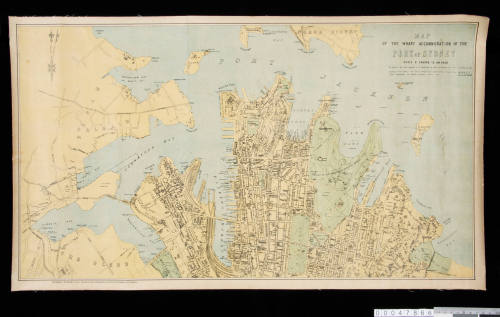
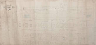
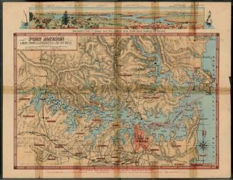
The Wharf Accommodation of the Port of Sydney
Publisher
McCarron, Stewart & Co
Datec 1926
Object number00047866
NameMap
MediumColoured ink on paper on linen
DimensionsOverall: 440 x 764 mm
ClassificationsMaps, charts and plans
Credit LineANMM Collection Gift from Ken Mackenzie
DescriptionThis map of the wharf accommodation of the Port of Sydney was published to accompany the 2nd edition of The Port of Sydney, N.S.W. Official Handbook of 1924.HistoryThis map of the wharf accommodation of the Port of Sydney was first published in The Port of Sydney, N.S.W. Official Handbook, by the Sydney Harbour Trust Commissioners in 1913, printed by McCarron, Stewart & Co., Printers and Lithographers, 22-26 Goulburn St, Sydney.
The map is scaled at 8 chains to an inch. It mainly shows the southern side of Sydney Harbour west to Balmain, and highlights wharves, maritime related buildings and railways.
From the 1870s the short jetties and piers in Walsh Bay and Darling Harbour serving the coastal trade were replaced with longer jetties of the finger-pier type. The map identifies these shipping company and industry related wharves such as Dibb's Wharves, Fraser's Wharves, Huddart Parker, Burns Philp and the Union Steamship Company's Wharves in Darling Harbour.
By 1890 overseas trade had congregated at the northern, outer end of Darling Harbour and the coastal trade was confined to the southern section. Further rail lines were built to service the area and reclamation walls were constructed between 1890 and 1910.
During the nineteenth century most of the wharves in Sydney were privately owned. With the need for increased regulation - particularly with poor sewerage, rat infestation in the wharves area and the outbreak of the bubonic plague, in 1901 the first port authority was formed - the Sydney Harbour Trust.
One of the Trust's many functions was to produce guides and information for the maritime industries such as the map of wharf accomodation. The Port of Sydney Official Handbook was regularly updated with new editions after the first issue in 1913.
SignificanceThe Port of Sydney Official Handbook was a widely used and important publication for maritime industries during the first half of the twentieth century. Issues of the handbook contained various foldout maps and guides. This map was a more robust version, produced separately to the handbook.
![Map of India [Southern part]](/internal/media/dispatcher/169122/thumbnail)
![Map of India [Northern part]](/internal/media/dispatcher/169123/thumbnail)
Higinbotham & Robinson
1893