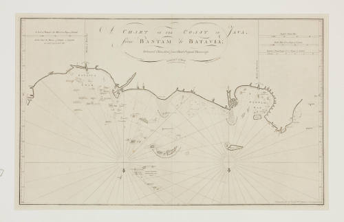


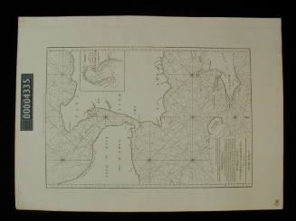
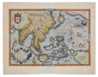
A chart of the coast of Java from Bantam to Batavia
Publisher
Henry Gregory
Date1777
Object number00007000
NameChart
MediumInk on paper
DimensionsOverall: 764 x 1039 mm, 6.4 kg
ClassificationsMaps, charts and plans
Credit LineANMM Collection
DescriptionThis chart shows the north coast of Java from Bantam to Batavia, with details of offshore reefs and islands. Published by Henry Gregory in 1777.HistoryDuring the 1600s the Dutch East India Company or Vereenigde Oostindische Compagnie (VOC) was a rapidly expanding merchant organisation. The VOC established a trade network throughout Asia by transporting rare spices, textiles and seeking new markets for their goods.
The town of Batavia (now Jakarta, Indonesia) became the headquarters for the VOC in Asia. The port was designed in a similar way to a Dutch city, complete with canals, bridges and a castle. Batavia served as a hub for the VOC Fleet. Products bought in various Asian regions were shipped to Batavia and then shipped to Europe or elsewhere in Asia. The town of Batavia was also the base for journeys of exploration to the unknown South Land.
William Herbert (1718-1795) was a surveyor, hydrographer, publisher and map seller specialising in sea charts. He was a member of the Drapers Company and served with the East India Company. Henry Gregory was publisher at 148 Leadenhall St, London who reissued Herbert's charts between 1777 and 1780 as "Herbert's Sea Charts". In 1787 he reissued Herbert's "New Directory for the East Indies".SignificanceThe Dutch settlement of Batavia (now Jakarta, Indonesia) was the base for exploration and trade by the Dutch in the Asian region during the 17th and 18th centuries.
Commander Frederick W Sidney
1953
Army Map Service, United States Army
1944