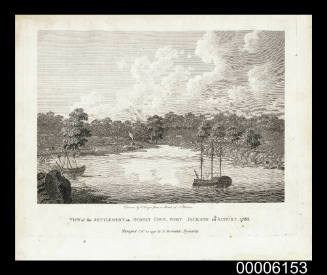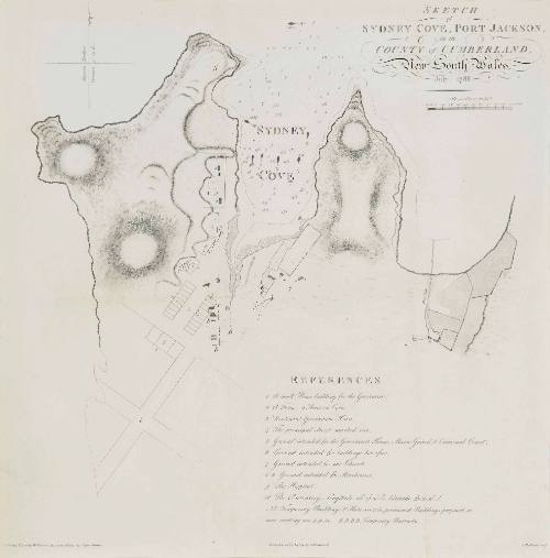
Sketch of Sydney Cove, Port Jackson
Publisher
John Stockdale
(1750 - 1814)
Engraver
Thomas Medland
(1755 - 1822)
Date1789
Object number00005998
NameChart
MediumInk on paper
DimensionsOverall: 477 x 494 mm, 0.05 kg.
ClassificationsMaps, charts and plans
Credit LineANMM Collection
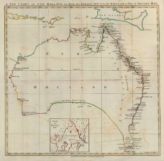
DescriptionThis chart of Sydney Cove, Port Jackson was published on 7 July 1789 and depicts survey work completed by Captain John Hunter and William Dawes only six months after the First Fleet arrived in 1788. It focuses on the area of present day Circular Quay, the Rocks, the Royal Botanic Gardens and Dawes Point. In this early stage of settlement no permanent buildings had been erected and the First Fleet arrivals lived ashore in tents.
HistoryAfter the First Fleet arrived in 1788 the settlement of Sydney initially consisted of a small group of tents and makeshift accommodation, much of which was built by the convicts themselves. Governor Phillip wanted to create a planned and structured settlement that wasn't hindered by the problems of overcrowding and congestion that cities in England experienced. Phillip wanted to 'preserve a kind of uniformity in the buildings, prevent narrow streets and exclude many inconveniences which a rapid increase in inhabitants might otherwise occasion'. His orders as Governor included ensuring building designs were standard and streets were a set width.
This chart was produced by William Dawes (coastline) and John Hunter (soundings) and published by Arthur Phillip in 'Voyage of Governor Phillip to Botany Bay with an account of the establishment of the colonies of Port Jackson and Norfolk Island'. It shows the location of a farm, buildings, proposed streets and relief shown by hachures and bathymetric soundings.SignificanceThis chart is one of the earliest surveys depicting the site of Sydney Cove. It demonstrates Governor Phillip's development plan for the settlement of Sydney after the First Fleet arrived.