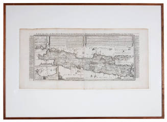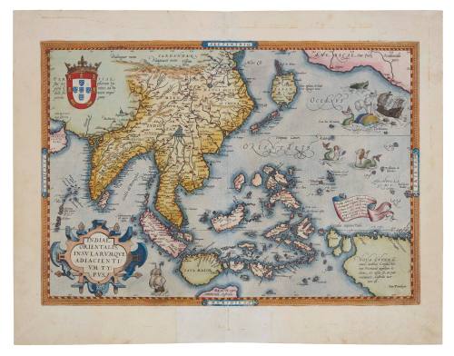
Indiae Orientalis, Insularumque Adiacientium Typus
Cartographer
Abraham Ortelius
(1527-1598)
Datec 1590
Object number00000918
NameMap
MediumInk on paper
DimensionsOverall: 350 × 495 mm
Mount / Matt size (C Fini Mount): 522 × 717 mm
Mount / Matt size (C Fini Mount): 522 × 717 mm
ClassificationsMaps, charts and plans
Credit LineANMM Collection
DescriptionMap by Abraham Ortelius titled 'Indiae Orientalis, Insularumque Adiacientium Typus' [East Indies and the Islands Adjacent]. Engraved map with later hand colouring depicting Indonesia (Java, Borneo, Celebes, Moluccas, Philippines, New Guinea) and a land mass south of Java that could be Australia described as 'BEACH, pars continentis Australis'. India, China, Japan and North America are also depicted.
In 1570, Flemish cartographer Abraham Ortelius compiled the so-called 'first modern atlas', the Theatrum Orbis Terrarum, a compilation of 53 maps of regions around the world, of which this map, the Indiae Orientalis, was one.
HistoryIn 1570, Flemish cartographer Abraham Ortelius (1527-1598), often called the 'father of modern geography', compiled what has been called 'first modern atlas', the Theatrum Orbis Terrarum. This compilation of 53 maps of regions around the world, included this map, the Indiae Orientalis.
The Indiae Orientalis is a brightly hand-coloured example, quite possibly produced for a particular client. Much of the information in the Indiae Orientalis is drawn from Gerhard Mercator's 1561 world map and from Portuguese maps. Despite being compiled from many sources, quite general in detail and initially with many errors, the Atlas was a popular publication and continued to be in demand in the early 1600s. It is unclear which year and edition this map is from.
At the bottom of the map a land mass described as 'BEACH, pars continentis Australis' is shown emerging below Java. This is reportedly based on Marco Polo's writings, which suggested the existence of a land below Java, and it has been argued that the word 'beach' is Polo's translation of a Chinese word. The reverse side of the map has text in Latin headed 'India'.
The publication of the Theatrum 'marked an epoch in the history of cartography'. As Tooley suggests, it was 'the first uniformly sized, systematic collection of maps of the countries of the world, based only on contemporary knowledge, since the days of Ptolemy.' Revised editions of the Theatrum expanded as new information about
the world gathered by explorers and traders reached Holland. See: Koeman, Atlantes Neerlandici, Volume III, Ort 11; Tooley, Maps and Mapmakers, pp. 29 & 106-108.
SignificanceWith its tantalising reference of a land mass below Java titled 'BEACH, pars continentis Australis', this is a highly significant map in the history of the European push to explore South Asia and the Pacific. It is also one of the earliest maps to possibly refer to the continent of Australia.
This map is part of what has been regarded as the first true world atlas, the Theatrum Orbis Terrarum. The importance of the Ortelius atlas in the history of cartography cannot be understated. It has been called the most influential atlas in history.
1901-1917