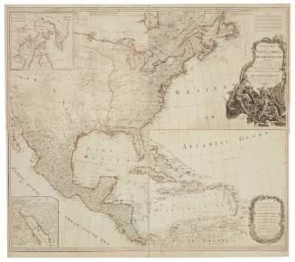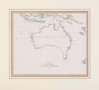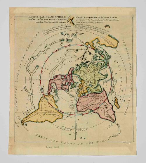
Physical Planisphere Wherein are Represented all the Known Lands and Seas with the Great Chains of Mountains which Traverse the Globe, from the North Pole
Model Maker
Philippe Buache
(French, 1700 - 1773)
Date1757
Object number00029305
NameMap
MediumColour print on paper
DimensionsImage: 320 x 294 mm
Overall: 362 x 312 mm, 0.01 kg
Sheet: 362 x 312 mm
Overall: 362 x 312 mm, 0.01 kg
Sheet: 362 x 312 mm
ClassificationsMaps, charts and plans
Credit LineANMM Collection
Collections
DescriptionA map titled 'Physical Planisphere Wherein are Represented all the Known Lands and Seas with the Great Chains of Mountains which Traverse the Globe, from the North Pole adapted to Monsr. Buache's Memoire read at the Royal Academy of Sciences'.
The North Pole is at the centre of the map with Australia (marked south continent / New Holland) at upper right corner. Australia is joined to New Guinea and has no East Coast. Part of New Zealand appears at top centre.HistoryPhillippe Buache was a gifted French cartographer apprenticed under Guillaume Delise and took over Delise's business after his death. He became geographer to the king in 1729 and entered the illustrious Academie des Scienes the following year.
Buache became known as a leader in 'theoretical geography', a way to fill in the gaps in the unknown parts of the globe. Based on a combination of astronomy, information from mariners, explorers and traders, Buache produced maps based on deductions and hypothesis. The most well-known of these is known as the 'Buache Map' where he depicts Antarctica (as yet unexplored) as two separate islands uncovered by ice.
Buache remains well known today as being the pioneer in the use of contour lines to express relief on maps.
SignificanceKnowledge of world geography was expanded greatly in the late 18th century as the powers in Europe raced each other to discover new regions. Gaps still remained however and this map by Buache, a leader in his field, depicts some of the calculated guess work that was taking place.