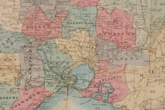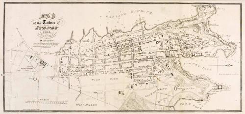
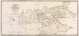
Map of the Town of Sydney
Engraver
William Wilson
(1795-1871)
Date1833
Object number00000857
NameMap
MediumInk on paper
DimensionsOverall: 182 x 396 mm
ClassificationsMaps, charts and plans
Credit LineANMM Collection
DescriptionThis map was produced for The New South Wales Calendar and General Post Office Directory of 1833. The Directory was an important reference guide in the nineteenth century, containing information on residents and businesses, towns and ports and travelling and shipping information.HistoryThis map was produced for The New South Wales Calendar and General Post Office Directory of 1833. It was issued as part of the series of plates that accompanied the Directory, including an engraved title-page, 2 folding tables, a folding hand-coloured plate of Colonial Signals, a folding plate of telegraph signals, a full-page engraved plan of Victoria Pass, 2 full-page engraved views, and 11 full-page illustrated trade advertisements.
The text includes a 'Sketch of the Colony', followed by a calendar for 1833 and directions if sailing, or travelling by road. The itinerary of roads lists all features (houses, mills, gates, bridges, stations, bush etc), as well as anecdotal information on some of the individual residents and business owners. The 'Rules and Regulations' section includes information on land assigned to convicts, county boundaries, discharged soldiers and ports and quarantine.
Parliamentarians, coroners, barristers, attorneys, surveyor-generals, surgeons, police, ministers of religion, schools and colleges, banks and insurance companies, auctioneers, mail coaches, exports, and arrivals and departures of vessels throughout the year are all listed. There is a section on the various military garrisons.
The Directory lists people alphabetically by surname, occupation and often both home and work address.
William Wilson (c.1795-c.1871) was an engraver and lithographer active in Sydney from the 1830s to the 1860s. In 1833 his business was on Queen Street, Sydney.SignificanceThis map is an accurate depiction of the township of Sydney in 1833. Combined with the General Post Office Directory information, it was an early version of a street directory. It provides a detailed snapshot of Sydney in 1833.
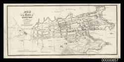
Higinbotham & Robinson
1893